

Auf den Spuren der Kelten von Perg nach Grein


- culturally interesting
Interactive elevation profile
Create PDF
Tour-Details
Starting place: 4320 Perg
Destination: 4360 Grein
duration: 1h 40m
length: 26,1 km
Altitude difference (uphill): 43m
Altitude difference (downhill): 33m
Lowest point: 227m
Highest point: 249m
difficulty: medium
condition: medium
panoramic view: Individual Views
Paths covering:
Asphalt
powered by TOURDATA
The fertile plain of the Machland and the wild and romantic landscape of the Strudengau form the backdrop to this tour.
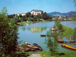
The starting point is the district capital of Perg. From here, the pedalling knights first cycle to Mitterkirchen. The "Celtic Village" open-air museum is the perfect place for a break and an expedition into the past. The route then continues along the Danube cycle path through green riparian forests. The scenery soon changes and the banks become steeper. The destination is the historic town of Grein under the watchful eye of the mighty Greinburg Castle, which can be seen from afar.
Route: On the R29 Machland cycle path towards Mitterkirchen, from there on the R1 Danube cycle path towards Grein
Most economical season
- Summer
Please get in touch for more information.
Lindengasse 9
4040 Linz
Phone +43 732 7277 - 800
Fax machine +43 732 7277 - 804
E-Mail info@donauregion.at
Web www.donauregion.at
http://www.donauregion.at
Interactive elevation profile
Create PDF
Tour-Details
Starting place: 4320 Perg
Destination: 4360 Grein
duration: 1h 40m
length: 26,1 km
Altitude difference (uphill): 43m
Altitude difference (downhill): 33m
Lowest point: 227m
Highest point: 249m
difficulty: medium
condition: medium
panoramic view: Individual Views
Paths covering:
Asphalt
powered by TOURDATA