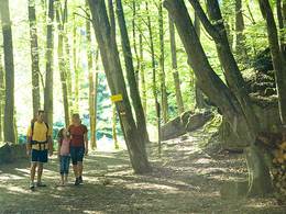
Hoamatlandweg


- pets allowed
Interactive elevation profile
Create PDF
Tour-Details
Starting place: 4173 St. Veit im Mühlkreis
Destination: 4172 St. Johann am Wimberg
duration: 1h 21m
length: 4,2 km
Altitude difference (uphill): 158m
Altitude difference (downhill): 156m
Lowest point: 685m
Highest point: 843m
difficulty: medium
condition: medium
panoramic view: Individual Views
Paths covering:
Hiking trail
powered by TOURDATA
The Hoamatlandweg trail leads from the town square in St. Veit through shady forest steeply uphill to the Hansberg. Along the 2.5 kilometre route, there are stations where you can learn more about the life and work of Hans Schnopfhagen. The trail leads to the snack station on the Hansberg at the Schnopfhagen monument.
- Suitable for groups
- Suitable for schools
- Pets allowed
- Spring
- Summer
- Autumn
Please get in touch for more information.
Phone +43 7217 6055
E-Mail gemeinde@st-veit.ooe.gv.at
Web www.sanktveit.at
http://www.sanktveit.at
Interactive elevation profile
Create PDF
Tour-Details
Starting place: 4173 St. Veit im Mühlkreis
Destination: 4172 St. Johann am Wimberg
duration: 1h 21m
length: 4,2 km
Altitude difference (uphill): 158m
Altitude difference (downhill): 156m
Lowest point: 685m
Highest point: 843m
difficulty: medium
condition: medium
panoramic view: Individual Views
Paths covering:
Hiking trail
powered by TOURDATA