

Mattigtal Bike Path R24


- Suitable for families
- culinary interesting
- culturally interesting
Interactive elevation profile
Create PDF
Tour-Details
Paths covering:
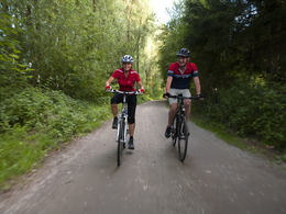
Precisely here is where the Mattigtal Bike Path begins and you follow it until the Mattig empties into the Inn. The bike path leads you through a particularly lovely corner of the Innviertel. Perwang, Jeging and Mattighofen are stops on the way. Near the historical commercial centre of Braunau, the Mattigtal Bike Path finally reaches the Inn Bike Path.
Designation: R24 (Within the network of national bike paths in Upper Austria)
further information:
- culinary interesting
- Board possible
Whether for arriving or departing or even for transfers along the route of the biking tour, trains are an irreplaceable partner when it comes to biking. With the right information for planning purposes, your next biking tour is quickly brought on track.
You can take the train to Neumarkt-Köstendorf to reach the Mattigtal Bike Path. After travelling approx. 2 kilometres on your way to Köstendorf, follow the Tannberg-Rundweg Path to the Salzkammergut cycle path and ride between Lake Matt, Lake Obertrummer and Lake Graben to the starting point in Perwang on Lake Graben. From the origins of the Mattig, the bike path leads through Jeging and Mattighofen into the historical commercial centre of Braunau on the Inn.
- Suitable for groups
- Spring
- Summer
- Autumn
Please get in touch for more information.
5280 Braunau am Inn
Phone +43 7722 62644
E-Mail info@entdeckerviertel.at
Web www.entdeckerviertel.at/
Interactive elevation profile
Create PDF
Tour-Details
Paths covering: