© Foto: Oberösterreich Tourismus GmbH/Robert Maybach: Gesellige Runde am Wolfgangsee
Gruppe junger Menschen auf einem Steg am Wolfgangsee

Alpine Foothills Bike Path R12

  • Suitable for families

 Interactive elevation profile

Download GPS data
Create PDF

Tour-Details

Path number: R12
Starting place: 4421 Aschach an der Steyr
Destination: 4614 Marchtrenk

duration: 2h 42m
length: 39,2 km
Altitude difference (uphill): 265m
Altitude difference (downhill): 287m

Lowest point: 299m
Highest point: 428m
difficulty: medium
condition: medium
panoramic view: Great panorama

Paths covering:
Asphalt

powered by TOURDATA

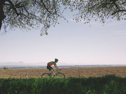
There is hardly a landscape considered as typically Upper Austrian as the Alpine foothills.


Whilst on the Alpine Foothills Bike Path, you will pass through the gently rolling hills of the fertile landscape. In Aschach an der Steyr, you enter the world of the stately "Vierkanthof" farmhouses. In Rohr, you cross the Kremtal Bike Path. Via Sipbachzell and Schleissheim, you reach your destination at the Marchtrenk power plant and can carry on to Wels via the Traun Bike Path.

Designation: R12 (Within the network of national bike paths in Upper Austria)

Starting point: Steyrtal Bike Path in Aschach an der Steyr, Sommerhubermühle
Destination: Traun Bike Path, Marchtrenk power plant

further information:
  • Board possible

Accessibility / arrival

Whether for arriving or departing or even for transfers along the route of the biking tour, trains are an irreplaceable partner when it comes to biking. With the right information for planning purposes, your next biking tour is quickly brought on track.

You can arrive by taking the train to Steyr. The Steyrtal Bike Path is a good option for getting to the starting point of the Alpine Foothills Path in Aschach an der Steyr. A further option for ambitious bikers is to bike from the railway station in Garsten via Saass to Aschach an der Steyr.

You can travel back by train from the finishing point at Wels' Main Train Station. After crossing the Traun on the Trodatbrücke, a bridge that was specially constructed for bikers and pedestrians, you bike through the historical centre of the trade fair city to the new hub for local travel.

Travelling by public transport
Route planner for independent travellers
Most economical season
  • Summer

Please get in touch for more information.


Alpine Foothills Bike Path R12
Oberösterreich Tourismus Information
Freistädter Straße 119
4041 Linz

Phone +43 732 221022
Fax machine +43 732 7277 - 701
E-Mail info@oberoesterreich.at
Web www.oberoesterreich.at/landesradweg…
https://www.oberoesterreich.at/landesradwege

We speak the following languages

German

 Interactive elevation profile

Download GPS data
Create PDF

Tour-Details

Path number: R12
Starting place: 4421 Aschach an der Steyr
Destination: 4614 Marchtrenk

duration: 2h 42m
length: 39,2 km
Altitude difference (uphill): 265m
Altitude difference (downhill): 287m

Lowest point: 299m
Highest point: 428m
difficulty: medium
condition: medium
panoramic view: Great panorama

Paths covering:
Asphalt

powered by TOURDATA