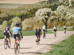
Eferdinger Landl Bike Path R18
Path number: R18
Starting place: 4070 Eferding
Destination: 4070 Eferding
The Eferdinger Landl Bike Path entices you away from the Danube and into the landscape in and around the Eferdinger Becken.
Designation: R18 (Within the network of national bike paths in Upper Austria)
Path number: R18
Starting place: 4070 Eferding
Destination: 4070 Eferding
duration: 5h 0m
length: 75,8 km
Altitude difference (uphill): 263m
Altitude difference (downhill): 259m
Lowest point: 255m
Highest point: 422m
difficulty: medium
condition: medium
panoramic view: Great panorama
Paths covering:
Asphalt
Starting point: Donauweg in Brandstatt
Destination: Donauweg in Brandstatt
further information:
- Flatly
- Board possible
Accessibility / arrival
The starting point is north of Eferding in Brandstatt, directly on the Danube at Gasthof Dieplinger.
By car:
West motorway (A1) Salzburg - exit Sattledt - Wels - Eferding
By rail:
Coming from Linz, take the Linzer Lokalbahn to Eferding.
Coming from Wels, take the Bundesbahn to Eferding.
Most economical season
- Spring
- Summer
- Autumn
Please get in touch for more information.
Freistädter Straße 119
4041 Linz
Phone +43 732 221022
Fax machine +43 732 7277 - 701
E-Mail info@oberoesterreich.at
Web www.oberoesterreich.at/aktivitaeten…
https://www.oberoesterreich.at/aktivitaeten/sommer/radfahren/landesradwege.html


