Viehberg trail to the summit
Path number: S3
Starting place: 4251 Sandl
Destination: 4251 Sandl
Sandl 28
4251 Sandl
4251 Sandl

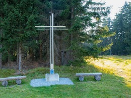
Via the Viehbergsteig to the summit cross at 1,112 metres!
Route:Town square - Schanzberg (former location of the ski jump) - cross the Viehberg goods road - Gipfelsteig - ski lift piste - summit cross - summit stone - detour to Maltschursprung - towards Maltschbachtal - back to Sandl
A wide range of maps and information material is available at the municipal office, at the information point on the town square, at the Sandl inns, at the Raiffeisenbank Sandl and at the SPAR department stores' in Sandl.
Path number: S3
Starting place: 4251 Sandl
Destination: 4251 Sandl
duration: 1h 15m
length: 5,5 km
Altitude difference (uphill): 210m
Altitude difference (downhill): 210m
Lowest point: 901m
Highest point: 1.114m
difficulty: medium
condition: medium
panoramic view: Great panorama
Paths covering:
Asphalt, Gravel
Starting point: Community square
Destination: Sandl town center
further information:
- Flatly
Accessibility / arrival
Coming from Linz via the A7 and S10 - exit Grünbach/Sandl - then continue on the B38 towards Sandl. You will find parking facilities in the town center.
Parking- Parking space: 20
- Parking area for disabled: 1
- Bus parking space: 2
- Charging point for electric cars (fees apply)
- Charging point for e-bikes (free of charge)
General price information
Free!
- Free entry
- Suitable for groups
- Suitable for schools
- Suitable for kids (all ages)
- Pets allowed
- Suitable for teenagers
- Suitable for seniors
- Suitable for single travelers
- Suitable for families
- Suitable for friends
- Suitable for couples
- Suitable for children
- Spring
- Summer
- Autumn
- Early winter
- Deep winter
Please get in touch for more information.
other information
- Toilet facility for disabled people: Community center
Sandl 28
4251 Sandl
Phone +43 7944 81006
E-Mail office@gasthof-fleischbauer.at


