Blue Trail - Let the scythes show you the way in Roßleithen
Starting place: 4575 Roßleithen
Destination: 4575 Roßleithen


Flatly
Bahnhofstraße 2
4575 Roßleithen
4575 Roßleithen

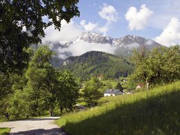
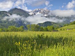
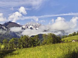
The BLUE PATH of the scythe theme trail in Roßleithen takes you over the Schweizersberg to the Stummerkogel and offers you descriptions of the farms, mountains and stories about the scythe. On the Stummerkogel (817m) there is a panoramic description of the entire mountain world.
Magnificent views of many mountain peaks in the region are described on informative pictures.Small "blue scythes" show them the way!
From the starting point at the hiking car park in Roßleithen you hike past the Gasthof Sengsschmied - elementary school - chapel - building yard - to the Gallbrunn snack bar. From here a hiking trail leads back to a supply road. Follow this uphill! From the Stummer estate, a hiking trail takes you to the "Stummer Kogel"!
Now follow this hiking trail in the direction of Roßleithen. You will soon reach the Schweizersberg freight route.
Follow this down the valley to the starting point “Wanderparkplatz”
Starting place: 4575 Roßleithen
Destination: 4575 Roßleithen
duration: 2h 30m
length: 6,9 km
Altitude difference (uphill): 213m
Altitude difference (downhill): 211m
Lowest point: 659m
Highest point: 817m
difficulty: medium
condition: medium
panoramic view: Great panorama
Paths covering:
Asphalt, Gravel
Starting point: Hiking car park in the center of Roßleithen
Destination: Hiking car park in the center of Roßleithen
further information:
- Flatly
- Board possible
Details - hiking
- themed path
")
Accessibility / arrival
Hiking car park in the center of Roßleithen
Most economical season
- Spring
- Summer
- Autumn
Please get in touch for more information.

Bahnhofstraße 2
4575 Roßleithen
Phone +43 7562 5266
Fax machine +43 7562 5266 - 10
E-Mail info@pyhrn-priel.net
Web www.urlaubsregion-pyhrn-priel.at/
https://www.urlaubsregion-pyhrn-priel.at/
Altitude profile - Blue Trail - Let the scythes show you the way in Roßleithen
powered by TOURDATA