Windischgarsten – around the Moosgierlerberg - Windischgarsten
Path number: 10
Starting place: 4580 Windischgarsten
Destination: 4580 Windischgarsten
Bahnhofstraße 2
4580 Windischgarsten
4580 Windischgarsten

From the town center of Windischgarsten, you will hike around the Moosgierlerberg and via Dörfl back to Windischgarsten.
Starting from the market square at the town hall in Windischgarsten, you will hike in the direction of Rosenau am Hengstpaß to the outdoor pool in Windischgarsten. Head to the right past the pool to the geology nature trail in the nature park.On the far end, you will hike on the Dümlerweg path along the brook and through the saw mill. Directly after the saw mill, you will go right into the village of Dörfl and then left, and you will follow the road straight to the Bischofsberg supply lane. Take a right here to Cafe Sophie and then left 100 m down the road.
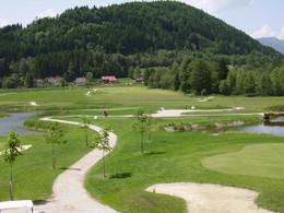
Follow the signs on the road to Gasthaus Moosgierler. Once there, you will hike through the farm and follow the farm road downhill to Hotel Huttersberg. Then, follow the road to Golf-Salettl.
At Golf-Salettl, you will continue along the right side of the street to the village, where you will turn left and then follow the road until you reach the starting point in Windischgarsten.
Path number: 10
Starting place: 4580 Windischgarsten
Destination: 4580 Windischgarsten
duration: 2h 40m
length: 9,4 km
Altitude difference (uphill): 196m
Altitude difference (downhill): 188m
Lowest point: 605m
Highest point: 789m
difficulty: easy
condition: easy
panoramic view: Individual Views
Paths covering:
Asphalt
Starting point: market square at the town hall in Windischgarsten
Destination: market square at the town hall in Windischgarsten
further information:
- Flatly
- Board possible
Details - hiking
- cleared winter hiking path
Accessibility / arrival
West motorway A1 - exit Voralpenkreuz on the A9 (Pyhrnautobahn) direction Graz - exit Roßleithen / Windischgarsten
Hauptbahnhof Linz - Windischgarsten
Graz - Selzthal - Windischgarsten
Airport Linz / Hörsching
Airport Salzburg / Wolfgang Amadeus Mozart
Graz Airport / Thalerhof
Most economical season
- Spring
- Summer
- Autumn
- Early winter
- Deep winter
Please get in touch for more information.
Bahnhofstraße 2
4580 Windischgarsten
Phone +43 7562 5266
Fax machine +43 7562 5266 - 10
E-Mail info@pyhrn-priel.net
Web www.urlaubsregion-pyhrn-priel.at
https://www.urlaubsregion-pyhrn-priel.at


