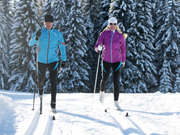
Wolfgang Valley cross-country ski trail
Starting place: 5350 Strobl
Destination: 5350 Strobl
Not in operation
The Wolfgangtalloipe in the Salzkammergut offers 17 km of groomed trails in classic and skating technique.
From the Golfhotel northwards along the road then westwards via Wirling and Radau to Rußbach. Here the short "Rußbach circular trail" can be incorporated. From Rußbach on level terrain again to Schwarzenbach, further on ot Mönichsreith and onto the connecting trail back to Strobl.
Starting place: 5350 Strobl
Destination: 5350 Strobl
duration: 2h 18m
length: 13,4 km
Altitude difference (uphill): 111m
Altitude difference (downhill): 112m
Lowest point: 506m
Highest point: 571m
difficulty: medium
condition: medium
panoramic view: Some Views
Paths covering:
snow
Starting point: Bus station in Strobl
Destination: Bus station in Strobl
further information:
- culinary interesting
- Flatly
- Possible accommodation
Details - Trail
- Nordic skiing facilities: Marked Nordic skiing run
- Type of Nordic skiing run: Skating
- free
December till February
001 Einstieg Rußbach
002 Abzweigung
003 Abzweigung 5 Mönichsreithrunde
004 Einstieg Schwarzenbach
005 Kreuzung Straße
006 Kreuzung Straße
007 Pöllmann Bauer
008 Abzweigung Abkürzung oben
009 Einstieg Golfhotel
010 Kreuzung Straße Wirling
011 Abzweigung Abkürzung
012 Kreuzung Straße
013 Ende Rußbacher Kreuzung
Accessibility / arrival
Starting points:
Bus station in Strobl (P), Bürgsteineck (Achen bridge) (P), Tourist Information in Schwarzenbach (P) 200 mts to trail, Kogler Bierstüberl (Inn) in Rußbach (P), Golfhotel in Aschau (P)
- Parking space: 20
General price information
free of charge
- Suitable for groups
- Suitable for schools
- Suitable for families
- Suitable for friends
- Suitable for couples
- Deep winter
Please get in touch for more information.
5360 St. Wolfgang im Salzkammergut
Phone +43 6138 8003
Fax machine +43 6138 8003 - 81
E-Mail info@wolfgangsee.at
Web wolfgangsee.salzkammergut.at
https://wolfgangsee.salzkammergut.at


