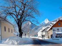
Winter Hiking on the village boardwalk
Starting place: 4573 Hinterstoder
Destination: 4573 Hinterstoder
According to the vernacular should be "daily" 1,000 steps do "to get yourself well-being and health." In the village promenade in Hinterstoder, the Ski World Cup field of holiday Pyhrn-Priel, this can easily meet daily workload.
Starting from the church square, you walk over the bridge to the other Wildmeister Steyr shore. Immediately after the bridge, the trail leads to the left of the buildings along the Württemberg'schen Forestry Administration. Over snowy meadows going, to get at the picturesque Stegergut over. A Straßerl continues to Huem Villa, a former smallholder Hube, which was converted into a hunting lodge in the early 20th century. After the bridge over the Steyr follow the path on the edge of the sports field, will pass the old, small forest house, to finally reach the village street. The sidewalk leads the way out of the valley, past the pretty Stoderer worldwide. Even from afar is the steeple already to see where the round finally closes. Starting place: 4573 Hinterstoder
Destination: 4573 Hinterstoder
duration: 0h 51m
length: 3,1 km
Altitude difference (uphill): 48m
Altitude difference (downhill): 45m
Lowest point: 584m
Highest point: 636m
difficulty: very easy
condition: very easy
panoramic view: Some Views
Paths covering:
snow
Starting point: Kirchenplatz Hinterstoder
Destination: Kirchenplatz Hinterstoder
further information:
- Flatly
- Board possible
Details - hiking
- cleared winter hiking path
Accessibility / arrival
Right in the center of Hinterstoder the winter hike begins on the village boardwalk.
- Suitable for pushchairs
- Spring
- Summer
- Autumn
- Early winter
- Deep winter
Please get in touch for more information.
Hinterstoder 38
4573 Hinterstoder
Phone +43 7564 5263 - 99
Fax machine +43 7564 5263 - 30
E-Mail hinterstoder@pyhrn-priel.net
Web www.urlaubsregion-pyhrn-priel.at
https://www.urlaubsregion-pyhrn-priel.at


