2. Etappe - Straubing bis Vilshofen
Starting place: 94315 Straubing
Destination: 94474 Vilshofen an der Donau
This stage runs mostly along the Danube and therefore has no gradients for long stretches. The route is full of great sights. If you leave the Danube to visit the Osterhofen and Aldersbach monasteries, which are particularly worth seeing, you will have to put up with a short climb.
Cyclists leave Straubing the same way they came, i.e. over the same bridges. After the Agnes Bernauer Bridge, the cycle path branches off to the right and leads through the same landscape as on the first day. However, the crest of the Bogenberg appears as we approach it. It is worth making a short detour to the abbey church of Oberaltaich, which, because it was built and decorated earlier, is not as grand as the later churches we pass, but it is still a beautiful early Baroque ensemble. Soon we are in the town of Bogen.The sporty cyclist, for whom the route is a pilgrimage route, should not miss the opportunity to climb the Bogenberg, 120 metres above the plain, with its pilgrimage church, 3 kilometres after Bogen.
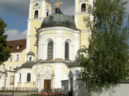
The journey continues along the Danube and its embankment. In Mariaposching, a ferry crosses the Danube. It is a "yaw rope ferry" which utilises the current of the river. It is operated by the two districts it connects. A few kilometres further on, we turn left towards Metten, whose twin-towered monastery church has been visible for some time.
We leave the market town of Metten in an easterly direction and after a few kilometres reach the district town of Deggendorf.
After Deggendorf, the northern hills come closer to the Danube again. The Isar flows into the river on the other bank. After a bathing pond, the famous Niederaltaich monastery is again on the left.
In Niederaltaich, a ferry crosses the Danube, so you can already cross to the other bank, otherwise you can do so on the large bridge that spans the river further down after a loop. On the south side, turn left and then cycle straight on via Ruckasing to Osterhofen. There you cycle through the town. The famous monastery church rises in the southern district of Altenmarkt. It can be reached via the Altstadt - Vorstadt - Bahnhofstraße road and, after passing under the railway, after a short climb.
Leave Altenmarkt in a southerly direction. At the next major crossroads after the end of the town, turn right and stay on this road, which first leads up over a hill and then rapidly down into the Vils valley. Then it's on to Aldersbach, where you can't miss the church tower and the brewery chimney. From 29 April to 30 October 2016, the House of Bavarian History, the district of Passau and the municipality of Aldersbach are organising the Bavarian State Exhibition 2016 "Beer in Bavaria" in collaboration with the Aldersbach brewery. The occasion is the 500th anniversary of the Bavarian Purity Law.
From Aldersbach, the route heads out of the valley, initially on the tarmac road, then turns left onto the signposted section of the River Vils, a narrow valley that leads directly into the town of Vilshofen.
>> Stage 3 - Regensburg to St. Wolfgang

01 Start Hotel Wenisch Straubing
Direction information: Departure

02 Bogenberg
Direction information: left

03 Metten Klosterkirche
Direction information: left

04 Deggendorf Oberer Stadtplatz
Direction information: straight ahead

05 Donaufähre Niederalteich
Direction information: left

06 Altenmarkt Osterhofen Klosterkirche
Direction information: left

07 Aldersbach Kloster und Brauerei
Direction information: left

08 Ende Vilshofen Wittelsbacher Zollhaus
Direction information: Destination
- All weather
- Suitable for groups
- Suitable for schools
- Suitable for families
- Spring
- Summer
- Autumn
Please get in touch for more information.
Au 140
5360 St. Wolfgang im Salzkammergut
Phone +43 6138 8003
Fax machine +43 6138 8003 - 81
E-Mail info@wolfgangsee.at
Web wolfgangsee.salzkammergut.at
https://wolfgangsee.salzkammergut.at


