

R201 Genussradtour


- Suitable for families
- culinary interesting
- culturally interesting
- Flatly
- Possible accommodation
Interactive elevation profile
Create PDF
Tour-Details
Path number: R 201
Starting place: 5280 Braunau am Inn
Destination: 5282 Braunau am Inn
duration: 5h 43m
length: 83,1 km
Altitude difference (uphill): 540m
Altitude difference (downhill): 541m
Lowest point: 338m
Highest point: 579m
difficulty: easy
condition: easy
panoramic view: Great panorama
Paths covering:
Asphalt, Gravel
powered by TOURDATA
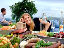
Pleasure bike tour - combine cycling with a stop for refreshments The "InnWirtler" restaurateurs along the route provide culinary delights and plenty of opportunities to rest. Most of the terrain is slightly hilly, but some climbs are rewarded with wonderful viewpoints.
The route can also be cycled in 2 parts as the Braunauer Runde (40 km) and Mattighofener Runde (58 km), as there is also a signposted connecting route between Neukirchen and Uttendorf!
The route can also be cycled in 2 parts as the Braunauer Runde (40 km) and Mattighofener Runde (58 km), as there is also a signposted connecting route between Neukirchen and Uttendorf!
- Suitable for groups
- Suitable for single travelers
- Suitable for friends
- Spring
- Summer
- Autumn
Please get in touch for more information.
5280 Braunau am Inn
Phone +43 7722 62644
E-Mail info@entdeckerviertel.at
Web www.entdeckerviertel.at
Web www.gps-tour.info/de/touren/detail.…
http://www.entdeckerviertel.at
http://www.gps-tour.info/de/touren/detail.93829.html
http://www.gps-tour.info/de/touren/detail.93829.html
Interactive elevation profile
Create PDF
Tour-Details
Path number: R 201
Starting place: 5280 Braunau am Inn
Destination: 5282 Braunau am Inn
duration: 5h 43m
length: 83,1 km
Altitude difference (uphill): 540m
Altitude difference (downhill): 541m
Lowest point: 338m
Highest point: 579m
difficulty: easy
condition: easy
panoramic view: Great panorama
Paths covering:
Asphalt, Gravel
powered by TOURDATA