

Pranzlgraben - Sonnseite


- Suitable for families
- Flatly
Interactive elevation profile
Create PDF
Tour-Details
Starting place: 4591 Molln
Destination: 4591 Molln
duration: 1h 15m
length: 4,0 km
Altitude difference (uphill): 165m
Altitude difference (downhill): 170m
Lowest point: 447m
Highest point: 610m
difficulty: easy
condition: easy
panoramic view: Some Views
Paths covering:
Asphalt, Path / trail, Gravel, Other
powered by TOURDATA
roadblock: Vorläufige Wegsperre
Short description:
Hike along the Pranzlgraben
Hike along the Pranzlgraben
Quality of experience: **
Recommended season:
- January
- February
- March
- April
- May
- June
- July
- August
- September
- October
- November
- December
Properties:
- Loop
- Family friendly
The hike leads up along the Pranzlgraben and via the Sonnseite back to the starting point.
Trail number: 18, 7
Directions:
We follow the idyllic rippling course of the Pranzlgraben. Above the marterl, the circular trail branches off to the left into a forest road.
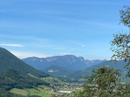
Enjoy the panoramic view of the Mollner Valley and the adjacent Tote Gebirge mountains. Via the sunny side you finally return to the starting point.
Tip:
Due to the sunny location, this hike is suitable for any season.
Starting point: Molln/Steiner-Kraml
Destination: Molln/Steiner-Kraml
further information:
- Flatly
Accessibility / arrival
Public Transit
The Steyrtal is served by bus lines 452 (Rohr-Bad Hall-Steinbach a. d. Steyr) and 433 (Steyr-Molln-Kirchdorf).
Parking
Molln
Getting there
From the west: A1 exit Sattledt > via Kremsmünster > Bad Hall > Steinbach an der Steyr
From the east: A1 exit Haag > Steyr > B140 into the Steyr valley
From the north: A3 Passau > Wels > A9 exit Sattledt > Kremsmünster > Bad Hall > Steinbach
From the south: A9 exit Klaus > into the Steyr valley
Public Transit
The Steyrtal is served by bus lines 452 (Rohr-Bad Hall-Steinbach a. d. Steyr) and 433 (Steyr-Molln-Kirchdorf).
Details at www.ooevv.at
With the Steyrtal Museum Railway www.steyrtalbahn.at
Parking
Molln
- Suitable for single travelers
- Suitable for friends
- Suitable for couples
- Spring
- Summer
- Autumn
- Early winter
- Deep winter
Please get in touch for more information.
Stadtplatz 27
4400 Steyr
Phone +43 7252 53229 - 0
E-Mail reichraming@steyr-nationalpark.at
Web www.steyr-nationalpark.at/
https://www.steyr-nationalpark.at/
Interactive elevation profile
Create PDF
Tour-Details
Starting place: 4591 Molln
Destination: 4591 Molln
duration: 1h 15m
length: 4,0 km
Altitude difference (uphill): 165m
Altitude difference (downhill): 170m
Lowest point: 447m
Highest point: 610m
difficulty: easy
condition: easy
panoramic view: Some Views
Paths covering:
Asphalt, Path / trail, Gravel, Other
powered by TOURDATA