Path Kalvarienberg
Path number: 1 im Plan
Starting place: 5360 St. Wolfgang im Salzkammergut
Destination: 5360 St. Wolfgang im Salzkammergut
Au 140
5360 St. Wolfgang im Salzkammergut
5360 St. Wolfgang im Salzkammergut

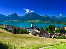
A beautiful, undulating walk high above St. Wolfgang, offering a splendid view of the lake and the surrounding mountains.
In the folder Winter Hiking Trails and Cross Country Skiing you can find the according numbers.
Path number: 1 im Plan
Starting place: 5360 St. Wolfgang im Salzkammergut
Destination: 5360 St. Wolfgang im Salzkammergut
duration: 1h 17m
length: 4,0 km
Altitude difference (uphill): 144m
Altitude difference (downhill): 146m
Lowest point: 541m
Highest point: 651m
difficulty: easy
condition: easy
panoramic view: Individual Views
Paths covering:
snow
further information:
- culinary interesting
- Flatly
- Possible accommodation
Details - hiking
- cleared winter hiking path
Parking
- Parking space: 20
- Parking area for disabled: 2
- Suitable for groups
- Suitable for schools
- Suitable for kids (3 - 6 Year)
- Suitable for families
- Spring
- Summer
- Autumn
- Early winter
- Deep winter
Please get in touch for more information.
Au 140
5360 St. Wolfgang im Salzkammergut
Phone +43 6138 8003
Fax machine +43 6138 8003 - 81
E-Mail st.wolfgang@wolfgangsee.at
Web wolfgangsee.salzkammergut.at
https://wolfgangsee.salzkammergut.at


