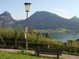
Panoramic circular route
Path number: 3
Starting place: 5360 St. Wolfgang im Salzkammergut
Destination: 5360 St. Wolfgang im Salzkammergut
An icredibly beautiful yet demanding run with a wonderful view over Lake Wolfgang and surrounding mountains.
Start at the Kurdirektion (tourist office) in St. Wolfgang. With the tunnel entrance behind you, leave the village, turning immediately left uphill, branch right and follow the road past the Rudolfshöhe (guesthouse) to the Hauslhof (farmstead), then uphill heading for the Jausenstation Holzerbauer. At the wayside shrine on the 2nd hairpin bend turn left going slightly downhill on the footpath, then up to the flat to the Ahornplatz. Straight on the Kalvarienberg church and soon after this, turn right onto a gravel path to just before the Hupfmühle (guesthouse). Take the road here 100m downhill then turn left via Roith (name of hamlet) to the Marketplace and back to the starting point.Distance: 6 km
Elevation difference: 80 m
Gravel-Course: 2 km
Tarmac-Course: 6 km
Time: 19 to 38 min
Nordic Walking: 66 min
Path number: 3
Starting place: 5360 St. Wolfgang im Salzkammergut
Destination: 5360 St. Wolfgang im Salzkammergut
duration: 1h 31m
length: 5,2 km
Altitude difference (uphill): 120m
Altitude difference (downhill): 128m
Lowest point: 551m
Highest point: 648m
difficulty: medium
condition: medium
panoramic view: Some Views
Paths covering:
Asphalt, snow
Starting point: Touristinfo St. Wolfgang
Destination: Touristinfo St. Wolfgang
further information:
- Flatly
Parking
- Parking space: 5
- All weather
- Suitable for groups
- Suitable for schools
- Suitable for families
- Suitable for friends
- Suitable for couples
- Spring
- Summer
- Autumn
Please get in touch for more information.
Au 140
5360 St. Wolfgang im Salzkammergut
Phone +43 6138 8003
Fax machine +43 6138 8003 - 81
E-Mail infof@wolfgangsee.at
Web wolfgangsee.salzkammergut.at
https://wolfgangsee.salzkammergut.at


