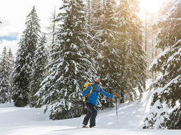
Gamskogel ski tour (tour area Sengsengebirge)
Starting place: 4572 St. Pankraz
Destination: 4572 St. Pankraz
The Gamskogel the Sengsengebirge is a little-visited mountain.
From the car park walk towards the devil's church (about 5 minutes - signs). On the Forstatraße proceed along the front Rescue Bach to Bartltalhütte (40 minutes). Of still there for 10 more minutes before you can see on the left a striking gorge. In the canyon you go now some switchbacks up to a trapdoor on the right that leads to a large clearing.Now keep left up to 1,100 meters and then cross right into the first trench. The path now leads through a steep gorge-like edge up, which is bounded on the left by rocks. Finally, ind he ever steeper and narrowing channel up until a trapdoor is possible. Caution! Channel often is blowing - snow board risk)
In flatter terrain proceed through larch forest to Uwe-Anderle bivouac and then right into a nice open terrain to the summit slope to Gamskogel up (about 30 minutes)
Starting place: 4572 St. Pankraz
Destination: 4572 St. Pankraz
duration: 4h 46m
length: 5,9 km
Altitude difference (uphill): 1.185m
Altitude difference (downhill): 95m
Lowest point: 553m
Highest point: 1.661m
difficulty: medium
condition: medium
panoramic view: Great panorama
Paths covering:
snow
Starting point: Parking in front of the devil's church
Destination: Parking in front of the devil's church
Details - Ski
- Descent: difficulty: medium, 1150 Metres of altitude
Accessibility / arrival
From the Pyhrnautobahn departure Hinterstoder / St. Pancrazio, turn right and after about 100 meters turn left into the service road Pernkopf. Now go under the railway and always follow the service road (approx. 4.5 km). Depending on snow conditions, you can drive up to the barrier.
Most economical season
- Deep winter
Please get in touch for more information.
Bahnhofstraße 2
4572 St. Pankraz
Phone +43 7562 5266
Fax machine +43 7562 5266 - 10
E-Mail info@pyhrn-priel.net
Web www.urlaubsregion-pyhrn-priel.at
https://www.urlaubsregion-pyhrn-priel.at


