Kasberg ski tour (tour area Steyrling)
Starting place: 4571 Klaus an der Pyhrnbahn
Destination: 4571 Klaus an der Pyhrnbahn
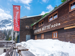
From Brunnental Steyrling on the Steyrerhütte the simple and safe tour goes to the Kasberg.
From the car park in Brunnental follow the tourist mark for Steyrerhütte . It goes through the Katzengraben always along the creek. In a sharp left turn and follow the signs " Steyrerhütte " 40 minutes. Go to the hut over to the flat pastureland to about 1,420 m. From here you have a tremendous overview . About the East side of Kasbergs and over bs exit variant of Ross hair. Now go up the flat at the beginning Almboden , later on the increasingly steep eastern slope to the summit cross of Kasberg .Departure:
Descent as ascent
or departure variant Ross Schopf:
At the summit , initially a bit left of the crest ( CAUTION : Snow board risk ) , to go straight along the back down towards Ross cropping up in the dump . Now for Gipfelstürmer it were 50 meters height hnauf to Ross hair. For the exit turn left over the first narrow steep gully down into the East Kar and on to Steyrerhütte .
The descent through the channel is only when safe conditions advisable , because otherwise there is considerable avalanche danger , however, by the north side exit is often a fantastic powder snow in the Karboden .
Starting place: 4571 Klaus an der Pyhrnbahn
Destination: 4571 Klaus an der Pyhrnbahn
duration: 7h 19m
length: 15,0 km
Altitude difference (uphill): 1.255m
Altitude difference (downhill): 1.089m
Lowest point: 560m
Highest point: 1.725m
difficulty: easy
condition: easy
panoramic view: Great panorama
Paths covering:
snow
Starting point: Brunnental Steyrling
Destination: Brunnental Steyrling
further information:
- Possible accommodation
- Board possible
Details - Ski
- Descent: difficulty: easy, 1190 Metres of altitude
- Snowboard suitable
Accessibility / arrival
Drive through the town of Steyr Ling back to the Brunnental, at the end of the road is a parking lot.
Most economical season
- Early winter
- Deep winter
Please get in touch for more information.
Hinterstoder 38
4571 Klaus an der Pyhrnbahn
Phone +43 7564 5263
Fax machine +43 7564 5263 - 30
E-Mail hinterstoder@pyhrn-priel.net
Web www.urlaubsregion-pyhrn-priel.at
https://www.urlaubsregion-pyhrn-priel.at


