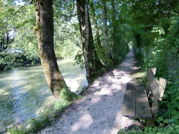
Schwarzenbach circular route
Path number: 5
Starting place: 5360 St. Wolfgang im Salzkammergut
Destination: 5360 St. Wolfgang im Salzkammergut
An easy, flat run on walking trails, mostly off-road.
Distance: 6 km
Elevation difference: 30 m
Gravel-Course: 5 km
Tarmac-Course: 1 km
Time: 19 to 36 min
Nordic Walking: 72 min
Path number: 5
Starting place: 5360 St. Wolfgang im Salzkammergut
Destination: 5360 St. Wolfgang im Salzkammergut
duration: 1h 33m
length: 5,4 km
Altitude difference (uphill): 117m
Altitude difference (downhill): 113m
Lowest point: 537m
Highest point: 619m
difficulty: easy
condition: easy
panoramic view: Some Views
Paths covering:
Asphalt, Gravel
Starting point: Sports grounds Schwarzenbach
Destination: Sports grounds Schwarzenbach
further information:
- Flatly
Accessibility / arrival
On the country road to St. Wolfgang,
on the left side there is a park car.
- Parking space: 100
- Suitable for kids (10 - 14 Year)
- Suitable for single travelers
- Suitable for friends
- Suitable for couples
- Spring
- Summer
- Autumn
Please get in touch for more information.
Au 140
5360 St. Wolfgang im Salzkammergut
Phone +43 6138 8003
E-Mail info@wolfgangsee.at
Web wolfgangsee.salzkammergut.at/
https://wolfgangsee.salzkammergut.at/


