

Themenweg 3: Gallinger Höhenweg barrierefrei


- Suitable for pushchairs
- Flatly
Interactive elevation profile
Create PDF
Tour-Details
Starting place: 4210 Gallneukirchen
Destination: 4210 Gallneukirchen
duration: 0h 37m
length: 2,3 km
Altitude difference (uphill): 28m
Altitude difference (downhill): 47m
Lowest point: 384m
Highest point: 429m
difficulty: easy
condition: easy
panoramic view: Some Views
Paths covering:
Asphalt, Hiking trail
powered by TOURDATA
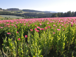
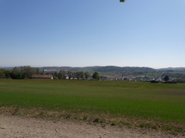
Accessible by car, starting point Tumbachberg - destination Gasthaus "Zur Alm". Route characteristics: asphalt and firm, asphalt-free path. Can be travelled easily. Wonderful high-level trail with marvellous views of the Gallneukirchen basin, Pfenningberg, on clear days of the Ötscher region, Ennstal Alps and Tote Gebirge mountains.

- Suitable for pushchairs
- Spring
- Summer
- Autumn
Suitable for wheelchairs: Not all of the legally stipulated ÖNORM are complied with. In principle, this object is suitable for wheelchairs and no assistance is necessary.
Reichenauer Straße 1
4210 Gallneukirchen
Phone +43 7235 63155
E-Mail stadtgemeinde@gallneukirchen.ooe.gv.at
Web www.gallneukirchen.at/STADT_er_lebe…
Web www.muehlviertel-urlaub.at/wandern
https://www.gallneukirchen.at/STADT_er_leben/Tourismus_Freizeit/Wanderwege
http://www.muehlviertel-urlaub.at/wandern
http://www.muehlviertel-urlaub.at/wandern
Interactive elevation profile
Create PDF
Tour-Details
Starting place: 4210 Gallneukirchen
Destination: 4210 Gallneukirchen
duration: 0h 37m
length: 2,3 km
Altitude difference (uphill): 28m
Altitude difference (downhill): 47m
Lowest point: 384m
Highest point: 429m
difficulty: easy
condition: easy
panoramic view: Some Views
Paths covering:
Asphalt, Hiking trail
powered by TOURDATA