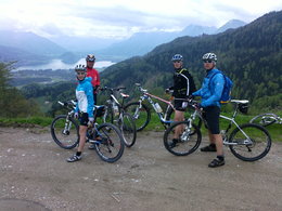
The Breitenberg Tour - around the Breitenberg Mountain
Starting place: 5350 Strobl
Destination: 5350 Strobl
The Breitenberg Mountain tour leads along the Blinklingmoos nature reserve and through idyllic alpine pastures to the summit of the Breitenberg Mountain, with its wonderful views over Lake Wolfgangsee.
Starting in Strobl, follow the “Salzkammergut Cycle Path” through the hamlet of Abersee to the hamlet of Brunn. An underpass leads under the main road (158) and continues on the Brunnergasse and Zinkenbachstraße. After 2 km, take the fork to the Breitenberg Mountain and follow route WO2 along a nice forest road around the summit of the Breitenberg Mountain. Descend by the same route until you reach the turning “Zinkenbachstraße”. The “Salzkammergut Cycle Path” then leads from the hamlet of Brunn via Abersee back to Strobl. Starting place: 5350 Strobl
Destination: 5350 Strobl
duration: 3h 29m
length: 36,9 km
Altitude difference (uphill): 870m
Altitude difference (downhill): 870m
Lowest point: 539m
Highest point: 1.278m
difficulty: medium
condition: medium
panoramic view: Some Views
Paths covering:
Asphalt, Gravel
further information:
- Flatly
details mountainbike
- Riding technique: medium
Accessibility / arrival
On the main road No. 158 you leave in Strobl and the tourist office Strobl is located directly in the center of Strobl. Public parking places are nearby.
- Parking space: 50
no
- Suitable for single travelers
- Suitable for friends
- Suitable for couples
- Spring
- Summer
- Autumn
Please get in touch for more information.
Au 140
5360 St. Wolfgang im Salzkammergut
Phone +43 6138 8003
E-Mail info@wolfgangsee.at
Web www.wolfgangsee.at
https://www.wolfgangsee.at
You can also visit us on
Facebook Instagram Pinterest YouTube


