

Zeissbergrundweg


- Suitable for families
- Flatly
Interactive elevation profile
Create PDF
Tour-Details
Path number: FR10
Starting place: 4240 Freistadt
Destination: 4240 Freistadt
duration: 5h 1m
length: 18,3 km
Altitude difference (uphill): 284m
Altitude difference (downhill): 284m
Lowest point: 543m
Highest point: 677m
difficulty: medium
condition: medium
panoramic view: Individual Views
Paths covering:
Hiking trail
powered by TOURDATA
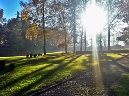
Together with the Gotikweg, the Zeißbergrunde FR 10 leads in a southerly direction from Freistadt. A large military cemetery invites you to reflect as you cross it. Approx. 200 metres after the railway crossing, the FR 10 branches off to the left to the south. Walk across meadows and forests past farms, past the Zeißberg to Unterzeiss and then follow the "Altstadt Freistadt" signs back.
Starting point: Hiking stone on the promenade by the Scheibling tower
Destination: Hiking stone on the promenade by the Scheibling tower
further information:
- Flatly
Accessibility / arrival
Coming from Linz, take the A7 motorway, then the B310 and then you can join the S10. Exit is Freistadt-Nord, from there you drive about 2 km back to Freistadt.
Coming from Prague on the B310 towards Freistadt.
- Parking space: 20
- Bus parking space: 2
No car park charges
- Suitable for groups
- Suitable for schools
- Suitable for single travelers
- Suitable for families
- Suitable for friends
- Suitable for couples
- Spring
- Summer
- Autumn
Please get in touch for more information.
Hauptplatz 1
4240 Freistadt
Phone +43 664 8325756
E-Mail office@freistadt.city
Web freistadt.city
Web www.muehlviertel-urlaub.at/wandern
https://freistadt.city
http://www.muehlviertel-urlaub.at/wandern
http://www.muehlviertel-urlaub.at/wandern
Interactive elevation profile
Create PDF
Tour-Details
Path number: FR10
Starting place: 4240 Freistadt
Destination: 4240 Freistadt
duration: 5h 1m
length: 18,3 km
Altitude difference (uphill): 284m
Altitude difference (downhill): 284m
Lowest point: 543m
Highest point: 677m
difficulty: medium
condition: medium
panoramic view: Individual Views
Paths covering:
Hiking trail
powered by TOURDATA