

Oberes Feldaisttal


- Suitable for families
- Flatly
Interactive elevation profile
Create PDF
Tour-Details
Path number: P4
Starting place: 4230 Pregarten
Destination: 4230 Pregarten
duration: 1h 22m
length: 5,0 km
Altitude difference (uphill): 83m
Altitude difference (downhill): 82m
Lowest point: 402m
Highest point: 441m
difficulty: medium
condition: medium
panoramic view: Individual Views
Paths covering:
Hiking trail
powered by TOURDATA
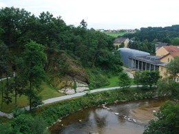
From the church square, cross the town square at the passageway next to the town hall and turn left across the car park down to the Kulturhaus Bruckmühle (which also houses the regional music school).
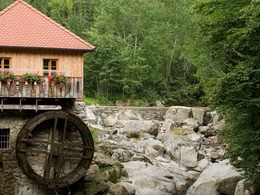
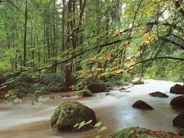
After the Aist bridge, turn right into the Obere Feldaisttal. The path continues along the Aist and crosses over to the other bank at the second bridge. There you will find a hammer mill from the 16th century. Turn left and you will soon reach the Pürmühle mill, which was owned by King Ottokar of Přemysl around 1251. Further upstream, you walk through the so-called Fuchsschweif, pass a beautiful pitch oil stone and cross a bridge to reach the Kumpfmühle, whose origins date back around 1000 years. The current owner has lovingly restored it over many years and is happy to show it to visitors as a museum. The path leads back down the right bank of the Aist to the bridge at the Ledermühle, a sawmill. From there, you walk uphill on a path, cross the railway and return to the start via Marktleiten and the car park behind the town hall.
After the Aist bridge, turn right into the Obere Feldaisttal. The path continues along the Aist and crosses over to the other bank at the second bridge. There you will find a hammer mill from the 16th century. Turn left and you will soon reach the Pürmühle mill, which was owned by King Ottokar of Přemysl around 1251. Further upstream, you walk through the so-called Fuchsschweif, pass a beautiful pitch oil stone and cross a bridge to reach the Kumpfmühle, whose origins date back around 1000 years. The current owner has lovingly restored it over many years and is happy to show it to visitors as a museum. The path leads back down the right bank of the Aist to the bridge at the Ledermühle, a sawmill. From there, you walk uphill on a path, cross the railway and return to the start via Marktleiten and the car park behind the town hall.
- Suitable for groups
- Suitable for teenagers
- Suitable for seniors
- Suitable for single travelers
- Suitable for friends
- Suitable for couples
- Spring
- Summer
- Autumn
- Early winter
Please get in touch for more information.
Stadtplatz 12
4230 Pregarten
Phone +43 7236 2255
E-Mail stadtamt@pregarten.ooe.gv.at
Web www.muehlviertel-urlaub.at/wandern
http://www.muehlviertel-urlaub.at/wandern
Interactive elevation profile
Create PDF
Tour-Details
Path number: P4
Starting place: 4230 Pregarten
Destination: 4230 Pregarten
duration: 1h 22m
length: 5,0 km
Altitude difference (uphill): 83m
Altitude difference (downhill): 82m
Lowest point: 402m
Highest point: 441m
difficulty: medium
condition: medium
panoramic view: Individual Views
Paths covering:
Hiking trail
powered by TOURDATA