Wieslerhorn
Starting place: 5350 Strobl
Destination: 5350 Strobl


Postalm
5350 Strobl
5350 Strobl

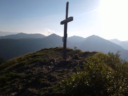
An easy and very popular hike on a mountain summit with its many lovely views.
From the end of car park 3, go right via the flat Almstraße road over to the huts on the Wiesleralm meadow. The red marked walking trail starts at the Erlbachhütte hut and leads over the meadows towards the west and the narrow summit is reached via a mountain ridge. Parking
- Parking space: 100
- Suitable for teenagers
- Suitable for seniors
- Suitable for friends
- Suitable for children
- Spring
- Summer
- Autumn
Please get in touch for more information.
Postalm
5350 Strobl
Phone +43 6137 7855
E-Mail strobl@wolfgangsee.at
Web wolfgangsee.salzkammergut.at
https://wolfgangsee.salzkammergut.at