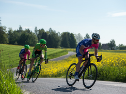
Borderline tour - To the Czech border and back
Path number: RR009
Starting place: 4600 Wels
Destination: 4600 Wels
This tour is the longest and most difficult in the region, 170 kilometres in length and 2,600 vertical metres.
Route plan:
ISOLA BELLA - Marchtrenk - ridges to Kirchberg/Thening - via the Danube and Ottensheim power station - up through Mühlviertel (Text about charm, solitude, views, culture such as Waxenberg, Haslach etc.) to the Czech border at Guglwald - Danube bridge at Aschach - Eferdinger Landl - Scharten - Wels / ISOLA BELLA
- Suitable for groups
- Suitable for single travelers
- Suitable for families
- Suitable for friends
- Suitable for couples
- Spring
- Summer
- Autumn
Please get in touch for more information.
Stadtplatz 44
4600 Wels
Phone +43 7242 67722 - 22
E-Mail info@wels.at
Web www.wels.at/welsmarketing/rennradre…
http://www.wels.at/welsmarketing/rennradregion-wels.html


