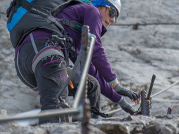
Kuckucksnest Via Ferrata Krippenstein
Short via ferrata at the south west face of the "Hohe Krippenstein" in the Holiday Region Dachstein Salzkammergut
Short and pretty via ferrata at the Dachstein Krippenstein
After a short entrance (A/B) the first face ist quite steep (B/C). Continuing climbers pass a mountain pine belt and arrive the nw face. Steep with few footholds (C) farther upwards, then easier (B/C), to a 1,5 meter, slightly overhanging passage (C). Climbers go on farther in the not so steep NW face (B to B/C) to a grassy passage, which leads to a rocky ascent (B to B/C). In the end the ferrata leads through some more mountain pines up to the top of the Krippenstein.
In case of emergency call the mountain rescue under 140
Download the via ferrata guide of Bad Goisern, Gosau at Dachstein, Hallstatt and Obertraun.
Experience a 360° panorama tour of the Dachstein Krippenstein…
Paths covering:
further information:
- Glacier region
- Board possible
Details - climbing mount
- difficulty acc. to Kurt Schall: medium difficulty (B)
- Hop off description: Ascent with the Dachstein Krippenstein cable car. After 550m hiking along the ski piste, turn right on a broad gravel trail follow that until you are at the entrance.
- Hop on description: At the end of the via ferrata hike up to the Krippenstein Lodge an then to the cable car.
The via ferrata is accessible from May to October, depending on snow and weather conditions.
by car
from Salzburg:
Federal road B158 direction Bad Ischl
in Bad Ischl driveway onto Salzkammergut Straße B145 in direction to Bad Goisern, Hallstatt and Obertraun, in Obertraun turn right direction Dachstein Krippenstein cable car
from Linz:
A1 motorway exit Regau on Salzkammergut Straße B145 direction Gmunden, Bad Goisern, Hallstatt and Obertraun, in Obertraun turn right direction Dachstein Krippenstein cable car
from Graz:
A9 motorway exit Liezen on B320
in Trautenfels turn onto Salzkammergut Straße B145 via Bad Aussee to Obertraun, in Obertraun turn left direction Dachstein Krippenstein cable car
from Villach:
A10 Tauernautobahn to exit "Eben im Pongau", from there via Annaberg, Gosau and Hallstatt to Obertraun, in Obertraun turn right direction Dachstein Krippenstein cable car
by bus:
get off at the bus station “Obertraun Dachsteinseilbahn”
by train:
from Linz/Salzburg to Attnang-Puchheim, change to train to Stainach-Irdning
or from Stainach-Irdning Zug direction Attnang-Puchheim
get off at train station "Obertraun-Dachsteinhöhlen", from there 45 minutes to walk or change to the bus
Detailed information on the respective train and bus times can be found at https://www.oebb.at/en/ (train) and https://www.postbus.at/en (bus).
- Parking space: 200
- Parking area for disabled: 5
- Bus parking space: 12
for free
E-service station / recharging station- Charging point for e-bikes (free of charge)
Here you can find the current price information of the Dachstein Krippenstein cable car.
- Summer
Please get in touch for more information.
Winkl 34
4831 Obertraun
Phone +43 50 140
E-Mail obertraun@dachstein-salzkammergut.at
Web www.dachstein-salzkammergut.com
You can also visit us on
Facebook Instagram Pinterest YouTube Wikipedia


