Via Ferrata Däumelkogel
A very scenic tour on the Dachstein Krippenstein with an easy and short rock climb on the Däumelkogel.
Beautifully scenic family via ferrata
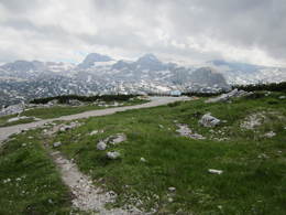
From Obertraun you can easily conquer 1,600 metres in altitude with the Dachstein Krippenstein cable car. You can enjoy the beauty of the karst landscape right from the ascent. From the mountain station on the Dachstein Krippenstein, first follow the wide hiking trail in the direction of Heilbronner Kreuz to the S, until you reach the fork in the trail No. 662 down to the Däumelsee and the Schönbergalm.
In the karst terrain you descend steeply to the beautiful Däumelsee and then up and down to the east, crossing directly towards the Däumelkogel. Shortly before the Däumelkogel, you will come to the path No. 664, which you follow to the saddle on the S side of the Kogel. From there, follow a path down the S flank of the mountain over a short belt of rocks in grassy terrain and through a belt of mountain pines to the summit cross.
On the descent, head back to the junction no. 664/662 and follow the partly steep trail through karst, rocks, roots and forest down to the Schönbergalm. From there, you can take the Dachstein Krippenstein cable car down the last section.
Our tip: Take some time to visit the Dachstein Giant Ice Cave or the Mammut Cave. Especially on hot summer days, this detour will offer you a pleasant refreshment
Experience a 360° panorama tour on the Dachstein Krippenstein...
In emergencies call the mountain rescue service on 140!
Download now: via ferrata guide for the villages of Bad Goisern, Gosau, Hallstatt and Obertraun.
Paths covering:
further information:
- Glacier region
Details - climbing mount
- difficulty acc. to Kurt Schall: difficult (C)
- Hop off description: The hiking tour starts from the mountain station of the Dachstein Krippenstein cable car.
- Hop on description: The descent to the Schönbergalm is not fully recommended, especially when it is wet. The climb then becomes dangerously slippery.
- duration hop on: 1 h
- duration Descent: 1 h
During Operating times of the Dachstein Krippenstein cable car the via ferrata is accessible from May to October, depending on snow and weather conditions.
By car
From Salzburg:
Bundesstraße B158 towards Bad Ischl
In Bad Ischl take the B145 Salzkammergut Straße towards Bad Goisern, Hallstatt and Obertraun, in Obertraun turn right towards Dachstein Krippenstein cable car
From Linz:
A1 motorway exit Regau on Salzkammergut road B145 direction Gmunden, Bad Goisern, Hallstatt and Obertraun, in Obertraun turn right direction Dachstein Krippenstein cable car
from Graz:
A9 motorway exit Liezen onto B320
In Trautenfels turn onto Salzkammergut road B145 via Bad Aussee to Obertraun, in Obertraun turn left towards Dachstein Krippenstein cable car
From Villach:
A10 Tauern motorway to exit "Eben im Pongau", from there via Annaberg, Gosau and Hallstatt to Obertraun, in Obertraun turn right towards Dachstein Krippenstein cable car
By bus:
to the stop "Obertraun Dachsteinseilbahn"
By train:
from Linz/Salzburg to Attnang-Puchheim, change to train to Stainach-Irdning
or from Stainach-Irdning train direction Attnang-Puchheim
get off at train station "Obertraun-Dachsteinhöhlen", from there approx. 45 minutes on foot or change to the bus
For detailed information on the respective train and bus times, please visit http://www.oebb.at (train) and www.postbus.at (Postbus)
- Parking space: 200
- Parking area for disabled: 5
- Bus parking space: 12
free of charge
E-service station / recharging station- Charging point for e-bikes (free of charge)
Here you can find the price information of the Dachstein Krippenstein cable car.
- Suitable for friends
- Suitable for couples
- Summer
Please get in touch for more information.
4831 Obertraun
Phone +43 6135 6058
E-Mail obertraun@dachstein-salzkammergut.at
Web www.dachstein-salzkammergut.at
You can also visit us on
Facebook Instagram Pinterest YouTube Wikipedia


