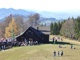
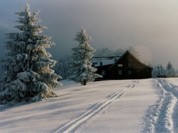
Grünburger Hütte (via Schreibachfall)
4400 Steyr

Hut hike from the Alpengasthof Klausriegler to the Grünburger Hütte
Recommended season:
- March
- April
- May
- June
- July
- August
- September
- October
- November
- December
- Round trip
- Refreshment stops available
From the parking at Alpengasthof Klausriegler, hiking trail E77 leads along a gravel road past the Schreibachfall, then uphill on trail 21 to Pfaffenboden. From there, take trail 483 to the Grünburger Hütte.
Through different variants, this hike can be extended to a round.
Trail number: E77, 21, 483
Directions:From the car park at Alpengasthof Klausriegler, hiking trail E77 leads along the level forest road to the Schreibachfall. The trail 21 then leads partly steeply uphill to Pfaffenboden. From there, trail 483 continues almost level to the Grünburger Hütte.
Variants:
- From the Schreibachfall, continue along trail 480a to the Buchberg Hut and via the Sulzboden (404/409) to the Grünburger Hut.
- From the Feitelmacher valley via the Hinterweyrmaier farmhouse and over the Sulzboden (404/409) to the Grünburger Hut.
- From the Schobersteinhaus via trail 482 or 483 to the Pfaffenboden and on to the Grünburger Hut.
Note:
A parking fee is payable at the Alpengasthof Klausriegler. If you consume something, you get a token to drive out.
Paths covering:
further information:
- Board possible
Current information about the Grünburgerhütte at www.gruenburgerhuette.or.at


Getting there
From Salzburg/Linz: A1 motorway exit Enns-Steyr > B115 into the Enns Valley.
From Vienna: A1 motorway exit Haag > B42 > B122 > B115 into the Enns Valley
From Passau: A8 Passau > Wels > A1 motorway exit Enns-Steyr > B115 into the Enns Valley
From Graz: A9 Pyhrnautobahn > motorway exit Klaus > Grünburg > into the Ennstal valley
Public Transit
The Ennstalbahn runs between Linz and Weißenbach-St. Gallen.
Details at www.ooevv.at
Railway Stations are located in Steyr, Garsten, Lahrndorf, Dürnbach, Ternberg, Trattenbach, Losenstein, Reichraming, Großraming, Gaflenz, Weyer, Küpfern, Kastenreith, Kleinreifling and Weißenbach-St. Gallen.
Parking
Trattenbach/Gasthaus Klausriegler - A parking fee is payable at the Alpengasthof Klausriegler. If you consume something, you get a token to drive out.
- Suitable for groups
- Suitable for seniors
- Suitable for single travelers
- Suitable for friends
- Suitable for couples
- Spring
- Summer
- Autumn
- Early winter
- Deep winter
Please get in touch for more information.
Stadtplatz 27
4400 Steyr
Phone +43 7252 53229 - 0
E-Mail reichraming@steyr-nationalpark.at
Web www.steyr-nationalpark.at/


