

Grünburger Hütte (via Ternberg and Herndleck)


- Possible accommodation
Interactive elevation profile
Create PDF
Tour-Details
Path number: 404
Starting place: 4452 Ternberg
Destination: 4596 Steinbach an der Steyr
duration: 3h 42m
length: 9,6 km
Altitude difference (uphill): 911m
Altitude difference (downhill): 180m
Lowest point: 348m
Highest point: 1.157m
difficulty: medium
condition: medium
panoramic view: Some Views
Paths covering:
Asphalt, Path / trail, Gravel, Hiking trail, Other
powered by TOURDATA
Short description:
On the long-distance hiking trail 404 from Ternberg to Grünburger Hütte
On the long-distance hiking trail 404 from Ternberg to Grünburger Hütte
Quality of experience: **
Recommended season:
- March
- April
- May
- June
- July
- August
- September
- October
- November
Properties:
- Round trip
- Refreshment stops available
- Summit route
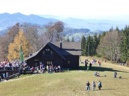
From the railway station, the long-distance trail 404 leads up to the Brandkogel and Herndleck and over the Gscheid to the Grünburger Hütte (1,080 m).
Trail number: 404
Directions:
From the railway station, the long-distance hiking trail 404 leads up to the Brandkogel and Herndleck. Continue via the Rehböden and Teufelskirche to the junction where hiking trail no. 13 branches off to the right to the Kruckenbrettl (1,020m), turn left via the Gscheid and Sulzboden to the Grünburger Hütte (1,080m).
Tip:
Climate-friendly to the National Park Region - railway station Ternberg: By train you can reach the starting point for this hike in about 1 hour from Linz and in about 2.5 hours from Vienna.
Additional information:
Alternative: The trail can be shortened by approx. 1.5 hours if you start from the Herndleck car park.
Starting point: Ternberg/railway station
Destination: Ternberg/railway station
further information:
- Possible accommodation
- Board possible

Bahnhof Ternberg

Gasthof Mandl

Gasthof Pension Kirchenwirt

Marktwirt Derfler
Accessibility / arrival
Public Transit
The Ennstalbahn runs between Linz and Weißenbach-St. Gallen.
Parking
Ternberg/railway station or shorter variation via parking Herndleck
Getting there
From Salzburg/Linz: A1 motorway exit Enns-Steyr > B115 into the Enns Valley.
From Vienna: A1 motorway exit Haag > B42 > B122 > B115 into the Enns Valley
From Passau: A8 Passau > Wels > A1 motorway exit Enns-Steyr > B115 into the Enns Valley
From Graz: A9 Pyhrnautobahn > motorway exit Klaus > Grünburg > into the Ennstal valley
Public Transit
The Ennstalbahn runs between Linz and Weißenbach-St. Gallen.
Details at www.ooevv.at
Railway Stations are located in Steyr, Garsten, Lahrndorf, Dürnbach, Ternberg, Trattenbach, Losenstein, Reichraming, Großraming, Gaflenz, Weyer, Küpfern, Kastenreith, Kleinreifling and Weißenbach-St. Gallen.
Parking
Ternberg/railway station or shorter variation via parking Herndleck
- Suitable for groups
- Suitable for seniors
- Suitable for single travelers
- Suitable for friends
- Suitable for couples
- Spring
- Summer
- Autumn
- Early winter
Please get in touch for more information.
Stadtplatz 27
4400 Steyr
Phone +43 7252 53229 - 0
E-Mail reichraming@steyr-nationalpark.at
Web www.steyr-nationalpark.at/
https://www.steyr-nationalpark.at/
Interactive elevation profile
Create PDF
Tour-Details
Path number: 404
Starting place: 4452 Ternberg
Destination: 4596 Steinbach an der Steyr
duration: 3h 42m
length: 9,6 km
Altitude difference (uphill): 911m
Altitude difference (downhill): 180m
Lowest point: 348m
Highest point: 1.157m
difficulty: medium
condition: medium
panoramic view: Some Views
Paths covering:
Asphalt, Path / trail, Gravel, Hiking trail, Other
powered by TOURDATA