

A13 von Alberndorf zur Pferdeeisenbahn


Interactive elevation profile
Create PDF
Tour-Details
Path number: A13
Starting place: 4211 Alberndorf in der Riedmark
Destination: 4211 Alberndorf in der Riedmark
duration: 1h 30m
length: 5,6 km
Altitude difference (uphill): 26m
Altitude difference (downhill): 204m
Lowest point: 383m
Highest point: 567m
difficulty: very easy
condition: very easy
panoramic view: Individual Views
Paths covering:
Asphalt, Hiking trail
powered by TOURDATA
Alberndorf - Aich - Luegstetten - Horse-drawn railway trail
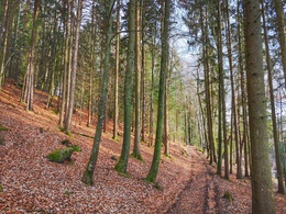
From the Spar, the hike first follows the Biblical Hiking Trail to the Mariengrotte. Continuing through the forest, you soon reach the goods road to Aich. After the "Klambauer" farmstead, turn left. Beautiful forest and field paths offer hikers a comfortable walk to their destination. The route of the former horse-drawn railway and the Gusental nature reserve lie ahead of you.
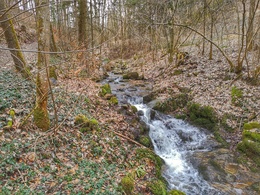
Beautiful beech forests provide plenty of shade on hot days on this tour. Most of the time, the sound of the Bürstenbach stream accompanies us on this route.
If you walk along the horse-drawn railway path for about 20 minutes in the direction of Neumarkt, you will reach a junction with a forest path. Following the forest path to the left or uphill, you have the option of returning to the starting point via Greifenberg and Oberweitersdorf (note: not an official hiking trail and not signposted!).
From the Spar, the hike first follows the Biblical Hiking Trail to the Mariengrotte. Continuing through the forest, you soon reach the goods road to Aich. After the "Klambauer" farmstead, turn left. Beautiful forest and field paths offer hikers a comfortable walk to their destination. The route of the former horse-drawn railway and the Gusental nature reserve lie ahead of you.
Beautiful beech forests provide plenty of shade on hot days on this tour. Most of the time, the sound of the Bürstenbach stream accompanies us on this route.
If you walk along the horse-drawn railway path for about 20 minutes in the direction of Neumarkt, you will reach a junction with a forest path. Following the forest path to the left or uphill, you have the option of returning to the starting point via Greifenberg and Oberweitersdorf (note: not an official hiking trail and not signposted!).


Parking
- Parking space: 30
- Parking area for disabled: 2
- Charging point for electric cars (fees apply)
- Charging point for e-bikes (free of charge)
Most economical season
- Spring
- Summer
- Autumn
- Early winter
Please get in touch for more information.
4211 Alberndorf in der Riedmark
Phone +43 7235 7155
E-Mail tourismusverband@alberndorf.ooe.gv.at
Web www.alberndorf.at
http://www.alberndorf.at
")
Interactive elevation profile
Create PDF
Tour-Details
Path number: A13
Starting place: 4211 Alberndorf in der Riedmark
Destination: 4211 Alberndorf in der Riedmark
duration: 1h 30m
length: 5,6 km
Altitude difference (uphill): 26m
Altitude difference (downhill): 204m
Lowest point: 383m
Highest point: 567m
difficulty: very easy
condition: very easy
panoramic view: Individual Views
Paths covering:
Asphalt, Hiking trail
powered by TOURDATA