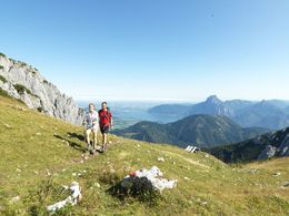
Via Maria Alpin-Variante 2
Starting place: 5310 St. Gilgen
Destination: 4463 Maria Neustift
Pilgrimage between Altötting and Maria Zell
The alpine variant mentioned here runs via Mondsee, St. Wolfgang and Ebensee to the Almsee and into the valleys of Steyr and Enns.
This alpine variant follows the long-distance hiking trail 06 and partly the European long-distance hiking trail E4 and is easy to complete in three days, but requires good weather and fitness. Alternatively, you can also start from St. Wolfgang. From here it is a two-day stage to Ebensee!
South of Steyr, the Via Maria meets the Upper Austrian Mariazellerweg coming from Linz
Starting place: 5310 St. Gilgen
Destination: 4463 Maria Neustift
duration: 54h 4m
length: 155,5 km
Altitude difference (uphill): 7.434m
Altitude difference (downhill): 7.448m
Lowest point: 375m
Highest point: 1.798m
difficulty: medium
condition: medium
panoramic view: Some Views
Paths covering:
Asphalt, Gravel, Hiking trail
Details - hiking
- themed path
Most economical season
- Spring
- Summer
- Autumn
Please get in touch for more information.
Hauptplatz 13
8630 Mariazell
Phone +43 3882 2366
mobile +43 664 1122115
E-Mail tourismus@mariazell-info.at
Web www.viamaria.at
http://www.viamaria.at


