

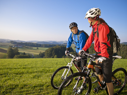
Donau-Moldau-Trail


Interactive elevation profile
Create PDF
Tour-Details
Path number: 3
Starting place: 4040 Linz
Destination: 38273 Vyšší Brod
duration: 5h 3m
length: 58,5 km
Altitude difference (uphill): 1.407m
Altitude difference (downhill): 1.096m
Lowest point: 253m
Highest point: 808m
difficulty: medium
condition: medium
panoramic view: Dreamtour
Paths covering:
Asphalt, Gravel
powered by TOURDATA
North-south connection from Linz through the Sterngartl Gusental region to Vyšší Brod. Starting from Linz on the MTB route L1 towards Haselgraben, continue on hilly terrain on the north-south route no. 3 through the Sterngartl Gusental region (marked in both directions) to the Schwedenschanze border crossing. On the Czech side, follow the S8 signs to Vyšší Brod.
details mountainbike
- Riding technique: medium
Parking
- Parking space: 100
- Charging point for e-bikes (fees apply)
- Suitable for groups
- Suitable for single travelers
- Suitable for couples
- Spring
- Summer
- Autumn
Please get in touch for more information.
Ringstraße 77
4040 Linz
Phone +43 7213 20930
E-Mail office@sterngartl-gusental.at
Web www.sterngartl-gusental-leader.at
http://www.sterngartl-gusental-leader.at
Interactive elevation profile
Create PDF
Tour-Details
Path number: 3
Starting place: 4040 Linz
Destination: 38273 Vyšší Brod
duration: 5h 3m
length: 58,5 km
Altitude difference (uphill): 1.407m
Altitude difference (downhill): 1.096m
Lowest point: 253m
Highest point: 808m
difficulty: medium
condition: medium
panoramic view: Dreamtour
Paths covering:
Asphalt, Gravel
powered by TOURDATA