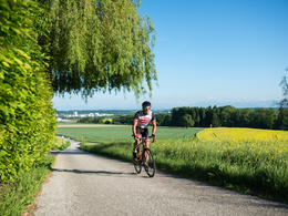
Runde vom Schloß Puchberg

 Interactive elevation profile

Download GPS data
Create PDF

Tour-Details

Starting place: 4600 Wels
Destination: 4600 Wels

duration: 0h 25m
length: 10,1 km
Altitude difference (uphill): 56m
Altitude difference (downhill): 56m

Lowest point: 320m
Highest point: 367m
difficulty: easy
condition: easy
panoramic view: Great panorama

Paths covering:
Street

powered by TOURDATA

The starting point is Puchberg Castle in the north of Wels. The 10-kilometre loop leads along asphalted, low-traffic farm roads in a slightly hilly agricultural landscape through the villages of Niederlaab, Mitterlaab and Roithen back to the grounds of Puchberg Castle.
Travelling by public transport
Route planner for independent travellers
Most economical season
  • Spring
  • Summer
  • Autumn

Please get in touch for more information.


Runde vom Schloß Puchberg
Tourismusverband Region Wels
Stadtplatz 44
4600 Wels

Phone +43 7242 67722 - 22
E-Mail info@wels.at
Web wels.at/rennrad
http://wels.at/rennrad

We speak the following languages

German

 Interactive elevation profile

Download GPS data
Create PDF

Tour-Details

Starting place: 4600 Wels
Destination: 4600 Wels

duration: 0h 25m
length: 10,1 km
Altitude difference (uphill): 56m
Altitude difference (downhill): 56m

Lowest point: 320m
Highest point: 367m
difficulty: easy
condition: easy
panoramic view: Great panorama

Paths covering:
Street

powered by TOURDATA