© Foto: Oberösterreich Tourismus GmbH/Robert Maybach: Gesellige Runde am Wolfgangsee
Gruppe junger Menschen auf einem Steg am Wolfgangsee

View from the north-west

 Interactive elevation profile

Download GPS data
Create PDF

Tour-Details

Starting place: 4600 Wels
Destination: 4600 Wels

duration: 1h 16m
length: 18,1 km
Altitude difference (uphill): 143m
Altitude difference (downhill): 145m

Lowest point: 321m
Highest point: 442m
difficulty: easy
condition: easy
panoramic view: Great panorama

Paths covering:
Street

powered by TOURDATA

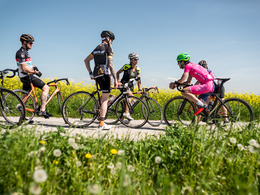
This loop starts at the car park of the Wels/Wimpassing leisure centre. Through Wimpassing, via Aichberg and Fernreith, after a short, crisp ascent to a terrace above Wels (Irrachanhöhe, 8 km.) With stunning views of the Alpine chain and the city to the south and as far as the Bohemian Forest to the north, weather permitting. After one kilometre turn left downhill towards Gunskirchen, from Fallsbach turn left via Grünbach on small roads back to the starting point. 18 km total length.
Travelling by public transport
Route planner for independent travellers
Most economical season
  • Spring
  • Summer
  • Autumn

Please get in touch for more information.


View from the north-west
Tourismusverband Region Wels
Stadtplatz 44
4600 Wels

Phone +43 7242 67722 - 22
E-Mail info@wels.at
Web www.wels.at/welsmarketing/rennradre…
https://www.wels.at/welsmarketing/rennradregion-wels.html

We speak the following languages

German

 Interactive elevation profile

Download GPS data
Create PDF

Tour-Details

Starting place: 4600 Wels
Destination: 4600 Wels

duration: 1h 16m
length: 18,1 km
Altitude difference (uphill): 143m
Altitude difference (downhill): 145m

Lowest point: 321m
Highest point: 442m
difficulty: easy
condition: easy
panoramic view: Great panorama

Paths covering:
Street

powered by TOURDATA