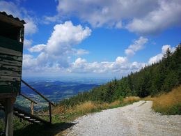
Hochsalm - mountainbike trail


Interactive elevation profile
Create PDF
Tour-Details
Starting place: 4644 Scharnstein
Destination: 4644 Scharnstein
duration: 2h 11m
length: 7,7 km
Altitude difference (uphill): 975m
Altitude difference (downhill): 205m
Lowest point: 486m
Highest point: 1.257m
difficulty: medium
condition: medium
panoramic view: Some Views
Paths covering:
Asphalt, Gravel
powered by TOURDATA
Mountain bike route on the Hochsalm
Our tip: From the turning point you can still climb the summit on foot along the hiking trail.
The descent is then on the same route!
We ask for consideration - because only through mutual consideration and fairness will it be possible to further expand the mountain bike network in the Almtal.
Information and cycling maps are available from the Traunsee-Almtal Tourist Office in the Almtal Tourist Office in Grünau im Almtal!
Please pay attention to the times of use and be considerate of other road users!
Parking
- Parking space: 15
- Suitable for single travelers
- Suitable for friends
- Spring
- Summer
- Autumn
Please get in touch for more information.
4644 Scharnstein
Phone +43 7616 8268
Fax machine +43 7616 8895
E-Mail almtal@traunsee-almtal.at
Web www.traunsee-almtal.at
Web www.scharnstein.ooe.gv.at/
https://www.traunsee-almtal.at
https://www.scharnstein.ooe.gv.at/
https://www.scharnstein.ooe.gv.at/
Interactive elevation profile
Create PDF
Tour-Details
Starting place: 4644 Scharnstein
Destination: 4644 Scharnstein
duration: 2h 11m
length: 7,7 km
Altitude difference (uphill): 975m
Altitude difference (downhill): 205m
Lowest point: 486m
Highest point: 1.257m
difficulty: medium
condition: medium
panoramic view: Some Views
Paths covering:
Asphalt, Gravel
powered by TOURDATA

