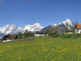
Großgrubrunde - "The Romantic"
Path number: Großgrubrunde "Die Romantische"
Starting place: 4574 Vorderstoder
Destination: 4574 Vorderstoder
From Steinergut a meadow path leads over the Furtbach to the well-visible Schaffergut. At the intersection Schaffer we keep to the right and after a short distance turn left into the Hammerlgraben. Along the wild and romantic Loigis and in the cool shade of the trees we hike slightly uphill. Soon we reach the parking lot Schafferteich. There are several attractive hiking opportunities, all of which are well signposted.
Path number: Großgrubrunde "Die Romantische"
Starting place: 4574 Vorderstoder
Destination: 4574 Vorderstoder
duration: 1h 30m
length: 4,3 km
Altitude difference (uphill): 117m
Altitude difference (downhill): 116m
Lowest point: 777m
Highest point: 871m
difficulty: easy
condition: easy
panoramic view: Great panorama
Paths covering:
Asphalt, Gravel, Hiking trail, Other
Starting point: Municipal office Vorderstoder
Destination: Municipal office Vorderstoder
further information:
- Flatly
Accessibility / arrival
Start and finish is located directly in the local center of Vorderstoder at the municipal office.
- Suitable for groups
- Suitable for schools
- Suitable for teenagers
- Suitable for seniors
- Suitable for single travelers
- Suitable for families
- Suitable for friends
- Suitable for couples
- Suitable for children
- Spring
- Summer
- Autumn
- Early winter
Please get in touch for more information.
Nr. 66
4574 Vorderstoder
Phone +43 7564 8255
Fax machine +43 7564 8255 - 20
E-Mail vorderstoder@pyhrn-priel.net
Web www.urlaubsregion-pyhrn-priel.at
https://www.urlaubsregion-pyhrn-priel.at


