Waldluftbadeweg Zelletau
Path number: Route mit blauen Legenden
Starting place: 4240 Freistadt
Destination: 4240 Freistadt
Waaggasse 6
4240 Freistadt
4240 Freistadt

Forest air bathing in Freistadt
Freistadt lies in the northern part of the Freistadt Basin, which is part of the Central Mühlviertel highlands. The urban organism is bordered by a horseshoe-shaped chain of hills and closed off to the south by the Jaunitz. In between, the life-giving Feldaist flows from north to south. The landscape centre of Freistadt is the Dreißgerberg (739 m). The Trölsberg in the south forms a separate landscape area with the Zeißberge on the edge of the Freistadt basin.
This trail also starts at the main square and leads through the Böhmertor gate down to Hafnerzeile, the historic craftsmen's quarter on the Feldaist at the gates of the town. After crossing the Feldaist, the ascent to the Stadtberg begins, which is rewarded with a breathtaking view over Freistadt.
From Oswalder Straße on the Stadtberg, the hiking trail leads through the forest to the Heiligensteiner forest clearing in Zelletau. The name of the farm already points to the ancient significance of the place, which is confirmed by the granite rocks in the ground in front of the farm.
The following "Flaps-Fit-Weg" through the Zelletau is a particularly family-friendly forest trail with many places of special interest. Back at the access road, the circular trail leads back to the Heiligensteiner clearing on the right or to the Haslinger farm on the left. There we cross Oswalder Straße and continue along the medieval adventure trail through a section of forest, where we come across a historic quarry on the left. The path continues to the alpine pasture. There the hiking trail crosses the Burgen- und Schlösserweg, on which we return through the Linzer Vorstadt and the Linzertor.
Side trip: The Jaunitz makes you forget for a moment how close you actually are to the vibrant centre of the district. Its confluence with the Feldaist on the southern border is a particularly impressive place.
Zelletau forest air bathing trail - waypoints
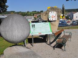
1. wandering stone
2. Hafnerzeile
3. town hill
4th Heiligensteiner
5. Zelletau
6. alpine pasture
7. dance floor
8th Linz suburb
This hiking trail is also possible as a snowshoe hiking trail (start on the city mountain in the Zeletau on the Flaps-Fit-Weg)
For guided tours, please contact our qualified forest air bathing masters - you can find more information here.
Path number: Route mit blauen Legenden
Starting place: 4240 Freistadt
Destination: 4240 Freistadt
duration: 2h 45m
length: 9,4 km
Altitude difference (uphill): 215m
Altitude difference (downhill): 220m
Lowest point: 553m
Highest point: 705m
difficulty: easy
condition: easy
panoramic view: No view
Paths covering:
Hiking trail, Other
Starting point: Hiking stone in Freistadt
Destination: Linzertor Freistadt
further information:
- Flatly
- Possible accommodation
Details - hiking
- themed path
- All weather
- Suitable for groups
- Suitable for schools
- Suitable for teenagers
- Suitable for seniors
- Suitable for single travelers
- Suitable for families
- Suitable for friends
- Suitable for couples
- Spring
- Summer
- Autumn
- Early winter
Please get in touch for more information.
Waaggasse 6
4240 Freistadt
Phone +43 5 07263 - 301
E-Mail badzell@muehlviertel.at
Web www.muehlviertel.at
Web www.muehlviertel-urlaub.at/wandern
https://www.muehlviertel.at
http://www.muehlviertel-urlaub.at/wandern
http://www.muehlviertel-urlaub.at/wandern


