Waldluftbadeweg Kuppenland Lasberg
Path number: Route mit grünen Legenden
Starting place: 4291 Lasberg
Destination: 4291 Lasberg
Waaggasse 6
4240 Freistadt
4240 Freistadt

Forest air bathing in Lasberg
The northern part of Lasberg lies in the Central Mühlviertel highlands and the southern part in the Aist-Naarn-Kuppenland. The central settlement and economic area of Lasberg, with the Feistritz river flowing through it, stretches out in between. The landscape centre of the northern highlands is the Haugenödtberg, the southern hilltop area the Buchberg. With these two landscape centres, Lasberg has a rich supply of vital energy and the wealth of two different landscape qualities that meet in the Feistritz valley.
From the village square, the hiking trail leads to the Kernland Museum "Spiralschmiede", Grieb 7; visits can be arranged by telephone on 07947/7391.
We walk on to Grieb, where we come across the old Maureder-Häusl. We can refresh our tree knowledge at the Druidenweg educational tree trail. The trail continues via Kaufleitn to Elz. The whole village and especially the village chapel is a place of power. The subsequent Pechölweg circular trail is a nature trail with two pitch oil stones. Back to the village square, you can take a break in the Elzer Stub'n or visit the village shop.
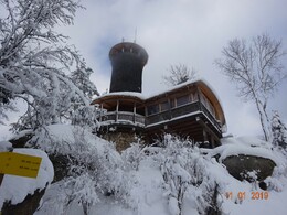
The way back leads us through a beautiful, mossy forest to the Schweingart estate and up the Buchberg (813m). Here there are numerous places with special effects: The summit with the fairy meadow, the Buchberghütte with the Hoh Haus viewing platform, a Schalenstein and a detour to the Augenbründl. There is a fridge with drinks in the tower of the Hoh Haus viewing platform. The Buchberghütte is open on Saturdays, Sundays and public holidays. Group bookings on 0664 2308273.
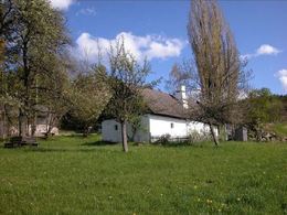
Return to the starting point via the Etzlstorfer Häusl museum. Walking time approx. 4 hours.
Waldluftbadeweg Kuppenland - Waypoints
1. hiking stone
2nd Etzlstorfer Häusl Museum
3. Buchberg, fairy meadow
4th Buchberg, summit
5. Buchberg, Hoh-Haus
6th Buchberg, Schalenstein
7th Buchberg, Augenbründl
8th Elz, chapel
9th Elz, Pechölsteine
10. druid path
11th Museum Spiralschmiede
For guided tours, please contact our qualified forest air bathing masters - you can find more information here.
Also suitable as a snowshoe trail in winter!
Tip: Buchberghütte is also open in winter on Saturdays, Sundays and public holidays in good weather!
Path number: Route mit grünen Legenden
Starting place: 4291 Lasberg
Destination: 4291 Lasberg
duration: 3h 34m
length: 11,2 km
Altitude difference (uphill): 394m
Altitude difference (downhill): 398m
Lowest point: 559m
Highest point: 811m
difficulty: easy
condition: easy
panoramic view: No view
Paths covering:
Hiking trail, Other
Starting point: Wanderstein Town square next to the municipal office
Destination: Wanderstein Town square next to the municipal office
further information:
- Flatly
Details - hiking
- themed path
- All weather
- Suitable for groups
- Suitable for schools
- Suitable for teenagers
- Suitable for seniors
- Suitable for single travelers
- Suitable for friends
- Suitable for couples
- Spring
- Summer
- Autumn
- Early winter
Please get in touch for more information.
Waaggasse 6
4240 Freistadt
Phone +43 5 07263 - 21
E-Mail freistadt@muehlviertel.at
Web www.waldluftbaden.at
http://www.waldluftbaden.at


