

The Emperor`s Tour - on the trail of the Habsburg Monarchy in Bad Ischl


- All weather
- Suitable for families
- culinary interesting
- culturally interesting
- Possible accommodation
Interactive elevation profile
Create PDF
Tour-Details
Starting place: 5350 Strobl
Destination: 5350 Strobl
duration: 1h 28m
length: 26,8 km
Altitude difference (uphill): 180m
Altitude difference (downhill): 180m
Lowest point: 466m
Highest point: 579m
difficulty: easy
condition: easy
panoramic view: Some Views
Paths covering:
Asphalt, Gravel
powered by TOURDATA
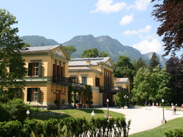
This tour is named after the Habsburg dynasty who, over the centuries, shaped the history of the Salzkammergut region, especially the town of Bad Ischl. Emperor Franz-Joseph was drawn to this lovely area, choosing it as his summer residence for more than 60 years.
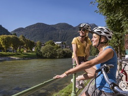
Starting in Strobl, take the “Salzkammergut Cycle Path” via the hamlet of Mönichsreith, Weinbach and Aigen to the village of Pfandl, and then along the very nice bank to the center of Bad Ischl. Return from Bad Ischl via the hamlet of Lindau to the restaurant Gasthof zur Wacht. From here rejoin the “Salzkammergut Cycle Path” back to Strobl. Starting point: Tourist Office Strobl
Destination: Tourist Office Strobl
further information:
- culinary interesting
- Possible accommodation
- Board possible
Accessibility / arrival
Exit the B158 in Strobl and the Strobl tourist office is located in the center of the village. Public parking places are nearby.
Parking- Parking space: 50
- Parking area for disabled: 2
no
- All weather
- Suitable for groups
- Suitable for schools
- Suitable for teenagers
- Suitable for seniors
- Suitable for single travelers
- Suitable for families
- Suitable for friends
- Suitable for couples
- Suitable for children
- Spring
- Summer
- Autumn
Please get in touch for more information.
Au 140
5350 St. Wolfgang im Salzkammergut
Phone +43 6138 8003
E-Mail info@wolfgangsee.at
Web www.wolfgangsee.at
https://www.wolfgangsee.at
You can also visit us on
Visit us on Facebook Visit us on Instagram Visit us on Pinterest Visit our videochannel on YouTubeInteractive elevation profile
Create PDF
Tour-Details
Starting place: 5350 Strobl
Destination: 5350 Strobl
duration: 1h 28m
length: 26,8 km
Altitude difference (uphill): 180m
Altitude difference (downhill): 180m
Lowest point: 466m
Highest point: 579m
difficulty: easy
condition: easy
panoramic view: Some Views
Paths covering:
Asphalt, Gravel
powered by TOURDATA