

Weg zum Braunberg


Interactive elevation profile
Create PDF
Tour-Details
Path number: GU 2
Starting place: 4293 Gutau
Destination: 4291 Lasberg
duration: 3h 12m
length: 10,3 km
Altitude difference (uphill): 414m
Altitude difference (downhill): 100m
Lowest point: 584m
Highest point: 898m
difficulty: medium
condition: medium
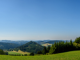
panoramic view: Great panorama
Paths covering:
Hiking trail, Other
powered by TOURDATA
Route
Gutau - St. Oswalderstraße - end of Gutau - Gusner - Faunlehner - Kagerer - Erdmannsdorf - Maria-Bründl Bezirksstraße - Ruhmer access road - Pengiseder - Flanitz - Witzelsberg - Braunberg
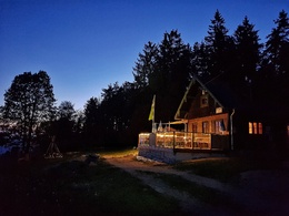
A shuttle trail for endurance hikers leads from Gutau to the Braunberg, where the rustic ÖAV hut offers a rest stop with a wonderful view and a hearty snack. From the start at the car park behind the Zeugfärberei dye works, the hiking signs lead into St. Oswalderstraße and after the "Zum Edi" inn, turn right up a meadow path into the Lehen goods road. The route continues uphill on tarmac past the Gusner and Gschwendenwein farms until gravel and meadows form the surface again on the left, past the Kagerer holiday farm and on to Erdmannsdorf with the "Zum Scharti" inn. Continuing north on the Maria Bründl district road, the Schaller-Schneider access road branches off after 750 metres, which then leads hikers uphill on a gravel path to the next road crossing. Continue via the Matzeneder access road and along the Flanitz up to Witzelsberg and the Braunberghütte (open from April to October).
Gutau - St. Oswalderstraße - end of Gutau - Gusner - Faunlehner - Kagerer - Erdmannsdorf - Maria-Bründl Bezirksstraße - Ruhmer access road - Pengiseder - Flanitz - Witzelsberg - Braunberg
A shuttle trail for endurance hikers leads from Gutau to the Braunberg, where the rustic ÖAV hut offers a rest stop with a wonderful view and a hearty snack. From the start at the car park behind the Zeugfärberei dye works, the hiking signs lead into St. Oswalderstraße and after the "Zum Edi" inn, turn right up a meadow path into the Lehen goods road. The route continues uphill on tarmac past the Gusner and Gschwendenwein farms until gravel and meadows form the surface again on the left, past the Kagerer holiday farm and on to Erdmannsdorf with the "Zum Scharti" inn. Continuing north on the Maria Bründl district road, the Schaller-Schneider access road branches off after 750 metres, which then leads hikers uphill on a gravel path to the next road crossing. Continue via the Matzeneder access road and along the Flanitz up to Witzelsberg and the Braunberghütte (open from April to October).
Most economical season
- Spring
- Summer
- Autumn
Please get in touch for more information.
St. Oswalderstraße 2
4293 Gutau
Phone +43 7946 6255
E-Mail gemeinde@gutau.ooe.gv.at
Web www.gutau.at/tourismus-freizeit.htm…
https://www.gutau.at/tourismus-freizeit.html
")
Interactive elevation profile
Create PDF
Tour-Details
Path number: GU 2
Starting place: 4293 Gutau
Destination: 4291 Lasberg
duration: 3h 12m
length: 10,3 km
Altitude difference (uphill): 414m
Altitude difference (downhill): 100m
Lowest point: 584m
Highest point: 898m
difficulty: medium
condition: medium
panoramic view: Great panorama
Paths covering:
Hiking trail, Other
powered by TOURDATA