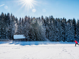
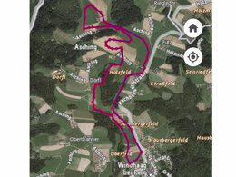
Loipe in Windhaag bei Perg
Starting place: 4322 Windhaag bei Perg
Destination: 4322 Windhaag bei Perg
Eva-Magdalena-Straße 7
4322 Windhaag bei Perg
4322 Windhaag bei Perg

Not in operation
The start of the cross-country ski trail in Windhaag bei Perg is opposite the residential buildings of the Heimstätte in Eva-Magdalena-Straße.
From the car park at the village square (church) it is approx. 250 m to the start.
Distance: 6 km, 250 metres in altitude
Duration 1.5 - 2 hours
Starting place: 4322 Windhaag bei Perg
Destination: 4322 Windhaag bei Perg
duration: 2h 0m
length: 6,0 km
Altitude difference (uphill): 111m
Altitude difference (downhill): 111m
Lowest point: 509m
Highest point: 584m
difficulty: medium
condition: medium
panoramic view: Individual Views
Paths covering:
snow
Starting point: The start is opposite the Heimstätte residential buildings on Eva-Magdalena-Straße. From the car park on the town square (church) it is about 250 m to the entrance.
Destination: The destination is opposite the Heimstätte residential buildings in Eva-Magdalena-Straße.
Details - Trail
- Suitable for seniors
- Suitable for friends
- Suitable for couples
- Deep winter
Please get in touch for more information.
Eva-Magdalena-Straße 7
4322 Windhaag bei Perg
Phone +43 7264 4255
E-Mail gemeinde@windhaag-perg.at
Web www.windhaag-perg.at/
https://www.windhaag-perg.at/


