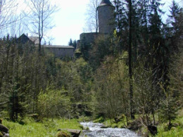
La 1 Dornachweg
Path number: La 1
Starting place: 4291 Lasberg
Destination: 4291 Lasberg
With the exception of the short steep section to the Dornach ruins, two thirds of the trail is on goods roads and one third on forest paths and climbs, with no gradients worth mentioning. A shortcut to the ruins is possible on the meditation trail. Worth seeing are the idyllic valley of the Feistritzbach stream, the open-air museum
"Fürstenhammer" open-air museum, the reservoir, the dreamy meditation trail, the private Dornach ruins, the Dornachhof "Hartmayer" farm and the views of the beautiful Mühlviertel cultural landscape. A section of the "Castles and Palaces Trail" also runs here.
We kindly ask you to pay attention to the notice "Temporary forestry
restricted area".
Path number: La 1
Starting place: 4291 Lasberg
Destination: 4291 Lasberg
duration: 1h 22m
length: 5,0 km
Altitude difference (uphill): 76m
Altitude difference (downhill): 78m
Lowest point: 531m
Highest point: 598m
difficulty: easy
condition: easy
panoramic view: Individual Views
Paths covering:
Hiking trail
Starting point: Market square to the west towards Pranger
Destination: Marketplace
further information:
- Flatly
- Suitable for single travelers
- Spring
Please get in touch for more information.
Markt 26
4240 Lasberg
Phone +43 7974 7255 - 13
E-Mail tourismuskern@lasberg.at
Web www.lasberg.at
Web www.muehlviertel-urlaub.at/wandern
https://www.lasberg.at
https://www.muehlviertel-urlaub.at/wandern
https://www.muehlviertel-urlaub.at/wandern


