© Foto: Oberösterreich Tourismus GmbH/Robert Maybach: Gesellige Runde am Wolfgangsee
Gruppe junger Menschen auf einem Steg am Wolfgangsee

La 3 Drei-Höfe-Weg

  • culinary interesting
  • Flatly

 Interactive elevation profile

Download GPS data
Create PDF

Tour-Details

Path number: La 3
Starting place: 4291 Lasberg
Destination: 4291 Lasberg

duration: 1h 9m
length: 4,1 km
Altitude difference (uphill): 82m
Altitude difference (downhill): 81m

Lowest point: 558m
Highest point: 634m
difficulty: medium
condition: medium
panoramic view: Some Views

Paths covering:
Asphalt, Path / trail, Hiking trail

powered by TOURDATA

Length: 4 km
Walking time: approx. 1 hour
Start/finish: from the market square southwards towards Freistritztal.
From the market square, the path leads into the Feistritztal valley. After a moderate ascent, the field and meadow path runs without any effort across the slope and down through the forest via Punkenhof back into the Feistritz Valley.
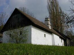
Really interesting and worth seeing is the "Etzlstorferhäusl" below the "Eder-Hof", a former hirer's house and private museum with a wonderful view of the market, the gentle hilly landscape and the little church "St. Michael ob der Rauchenödt".
The mighty old farms were once "Freisitze" (Frodnach = front farmer).
The "Punkenhof" is now a modern riding centre with an indoor arena
Tip:
Beautiful riding trail

Travelling by public transport
Route planner for independent travellers
  • Suitable for groups
  • Suitable for teenagers
  • Suitable for single travelers
Most economical season
  • Spring
  • Summer
  • Autumn

Please get in touch for more information.


La 3 Drei-Höfe-Weg
Tourismuskern Lasberg
Markt 26
4240 Lasberg

Phone +43 7947 7255 - 13
E-Mail tourismuskern@lasberg.at
Web www.lasberg.at
Web www.muehlviertel-urlaub.at/wandern
https://www.lasberg.at
https://www.muehlviertel-urlaub.at/wandern

We speak the following languages

German

 Interactive elevation profile

Download GPS data
Create PDF

Tour-Details

Path number: La 3
Starting place: 4291 Lasberg
Destination: 4291 Lasberg

duration: 1h 9m
length: 4,1 km
Altitude difference (uphill): 82m
Altitude difference (downhill): 81m

Lowest point: 558m
Highest point: 634m
difficulty: medium
condition: medium
panoramic view: Some Views

Paths covering:
Asphalt, Path / trail, Hiking trail

powered by TOURDATA