La 4 Almrunde
Path number: La 4
Starting place: 4291 Lasberg
Destination: 4291 Lasberg
The first third of the route leads steadily uphill, with some steeper sections towards the end, on farm and forest paths to the Kopenberg and the "Alm".
After the first 100 meters in altitude, there is a beautiful view of Lasberg, Weinberg Castle and the Feldaisttal valley as far as the Danube, and on clear days a magnificent view of the Alps.
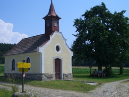
Heidenstein, Hofbauernkreuz, Kinderkreuze and Hofbauernkapelle, but also ancient stone cairns, the stone dumps of the granite quarry, the dreamy Hinterlehnerhof and the enchanted "Green Pond" line the mainly shady hiking trail.
Tip:
The tour becomes more meditative with the ascent of the steep "Kinderkreuzweg" trail
Path number: La 4
Starting place: 4291 Lasberg
Destination: 4291 Lasberg
duration: 2h 29m
length: 7,9 km
Altitude difference (uphill): 265m
Altitude difference (downhill): 260m
Lowest point: 574m
Highest point: 782m
difficulty: medium
condition: medium
panoramic view: Great panorama
Paths covering:
Asphalt, Path / trail, unfixed, Hiking trail
Starting point: Marketplace to the north in the direction of Hagelgasse
Destination: Marketplace
further information:
- Flatly
- Experience of nature
Most economical season
- Spring
- Summer
- Autumn
Please get in touch for more information.
Markt 26
4240 Lasberg
Phone +43 7947 7255 - 13
E-Mail tourismuskern@lasberg.at
Web www.lasberg.at
Web www.muehlviertel-urlaub.at/wandern
https://www.lasberg.at
https://www.muehlviertel-urlaub.at/wandern
https://www.muehlviertel-urlaub.at/wandern


