La 6 Mühlenweg
Path number: La 6
Starting place: 4291 Lasberg
Destination: 4291 Lasberg


Partial lock: Sperre Brücke Pührmühle
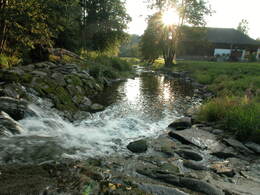
since 22.09.2024 This hiking trail leading into the beautiful Feldaisttal valley runs almost entirely on field and forest paths without any significant inclines. The Krumpmühle, the "Sternhäusl" and the Pührmühle are idyllically situated.
The historic Freistadt town hiking trail crosses here. The hiking trail is lined with old house chapels and stone martel. In the town, it leads past the "Alte Marktschmiede" open-air museum.
Path number: La 6
Starting place: 4291 Lasberg
Destination: 4291 Lasberg
duration: 2h 25m
length: 8,1 km
Altitude difference (uphill): 220m
Altitude difference (downhill): 220m
Lowest point: 517m
Highest point: 669m
difficulty: easy
condition: medium
panoramic view: No view
Paths covering:
Asphalt, Path / trail, Hiking trail
Starting point: Market square to the west towards Marktschmiede to Edlau
Destination: Marketplace
further information:
- Flatly
")
")
Most economical season
- Spring
- Summer
Please get in touch for more information.
Markt 26
4240 Lasberg
Phone +43 7947 7255 - 13
E-Mail tourismuskern@lasberg.at
Web www.lasberg.at
Web www.muehlviertel-urlaub.at/wandern
https://www.lasberg.at
https://www.muehlviertel-urlaub.at/wandern
https://www.muehlviertel-urlaub.at/wandern