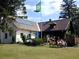
La 7 Braunberg
A well-known, popular, but somewhat steeper hike leads up the Braunberg (over 902 m high) to the only Alpine Club hut in the Mühlviertel. Wonderful views of the Alps! The 140 km long Nordwaldkammweg trail leads over the Braunberg to Freistadt or, like O 6, to St. Oswald. The Braunberg can also be "climbed" by car, by bike or - for the sporty - by mountain bike. Along the way, it is worth making a detour to the Grensberg summit with its former refuge and the interesting rock information point of the "Grafenhalt".
Tip 1:
A short walk to the eastern summit is highly recommended.
Tip 2:
Short variant: Descend from the hut to the west on the blue and white Kammenweg markings through rock and forest quite steeply to the "Innendorfer" and back to Lasberg on the familiar path. Long variant: See "Vier-Berge-Weg" La 9 from Braunberg!
For train travelers: From the inn to the stop on La 5/8/9 via Dornach to Lasberg.
Paths covering:
further information:
- Flatly
- Experience of nature
Opening hours of the Braunberghütte:
1 April to 31 October
Tuesday-Friday: 10-22:00 Saturday/Sunday: 09-22:00
- Spring
- Summer
Please get in touch for more information.
Markt 26
4240 Lasberg
Phone +43 7947 7255 - 13
E-Mail tourismuskern@lasberg.at
Web www.lasberg.at
Web www.muehlviertel-urlaub.at/wandern
https://www.muehlviertel-urlaub.at/wandern


