

natur.BANK.wege | Gaflenz | Heiligenstein | 333401


- Suitable for families
- culturally interesting
Interactive elevation profile
Create PDF
Tour-Details
Starting place: 3334 Gaflenz
Destination: 3335 Gaflenz
duration: 0h 15m
length: 0,6 km
Altitude difference (uphill): 88m
Lowest point: 678m
Highest point: 766m
difficulty: easy
condition: easy
panoramic view: Dreamtour
Paths covering:
Asphalt, Path / trail
powered by TOURDATA
Short description:
On the way to the pilgrimage site to St. Sebald, visible from afar, high above Gaflenz
On the way to the pilgrimage site to St. Sebald, visible from afar, high above Gaflenz
Quality of experience: ****
Recommended season:
- January
- February
- March
- April
- May
- June
- July
- August
- September
- October
- November
- December
Properties:
- Scenic
- Family friendly
- Cultural/historical value
- Botanical highlights
Actually a relatively short but very rewarding hike to the natur.bank, after the first car park is already very high up.
Directions:
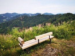
Coming from the car park, the nature trail leads partly on forest paths and partly on the access road to the Heiligenstein. The nature bench stands on the highest elevation of the trail and offers a magnificent view of the Lindau wall.
Tip:
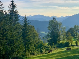
The hike up the Heiligenstein not only offers a magnificent view of Gaflenz and the peaks of the Almkogel, the Bodenwies, the Gesäuseberge and the Haller Mauern, but also leads to a traditional place of pilgrimage, the Sebalduskirche.
Starting point: Heiligenstein car park above the Edtbauer riding stables
Destination: natur.Bank.wege Heiligenstein
further information:
Accessibility / arrival
Parking
Heiligenstein car park
Getting there
By car from Linz: A1 motorway exit Enns-Steyr > B115 into the Enns Valley
By car from Vienna: A1 motorway exit Amstetten West > Waidhofen / Ybbs > Weyer
Parking
Heiligenstein car park
Most economical season
- Spring
- Summer
- Autumn
- Early winter
- Deep winter
Please get in touch for more information.
Stadtplatz 27
4400 Steyr
Phone +43 7252 53229 - 0
E-Mail info@steyr-nationalpark.at
Web www.steyr-nationalpark.at/
https://www.steyr-nationalpark.at/
Interactive elevation profile
Create PDF
Tour-Details
Starting place: 3334 Gaflenz
Destination: 3335 Gaflenz
duration: 0h 15m
length: 0,6 km
Altitude difference (uphill): 88m
Lowest point: 678m
Highest point: 766m
difficulty: easy
condition: easy
panoramic view: Dreamtour
Paths covering:
Asphalt, Path / trail
powered by TOURDATA