

natur.BANK.wege | Großraming | Bürscher | 446306


- Suitable for families
- culturally interesting
Interactive elevation profile
Create PDF
Tour-Details
Starting place: 4463 Großraming
Destination: 4463 Großraming
duration: 2h 0m
length: 6,0 km
Altitude difference (uphill): 375m
Altitude difference (downhill): 61m
Lowest point: 375m
Highest point: 720m
difficulty: medium
condition: difficult
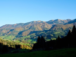
panoramic view: Dreamtour
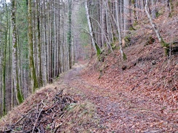
Paths covering:
Asphalt, Path / trail, Gravel, Hiking trail, Other
powered by TOURDATA
Short description:
Hike through the picturesque Sandlucke
Hike through the picturesque Sandlucke
Quality of experience: *****
Recommended season:
- April
- May
- June
- July
- August
- September
- October
Properties:
- Round trip
- Family friendly
- Cultural/historical value
No summit climb, but beautiful hike into the picturesque Sandluckengraben
Directions:
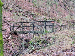
From the railway car park, the path leads into the Rodelsbach stream, past a few houses, left over the bridge into the Spriedelgraben and straight on along the stream into the idyllic "Sandluckengraben". From there you come to the bench above the Bürscher farmhouse.
Tip:
The best option is to continue down into the Lumplgraben, where you return to the station along the stream.An alternative is also the ascent of the Hiaslberg, in which one crosses the crossroads on the descent from the Bürscher and at the Hirner farmhouse hikes left along the forest path in the direction of the Hiaslberg.
Starting point: Großraming railway station
Destination: natur.BANK.wege Bürscher
further information:
Accessibility / arrival
Public Transit
Arrival via the Ennstalbahn runs between Linz and Weißenbach-St. Gallen. Stations are located in Ternberg, Trattenbach, Losenstein, Reichraming, Großraming, Küpfern, Kastenreith, Kleinreifling and Weißenbach-St. Gallen.
Parking
Großraming train station
Getting there
Oö. Ennstal:
From Salzburg/Linz: A1 exit Enns-Steyr /B115
From Vienna: A1 exit Haag/B42/B122/B115
From Passau: A8 Passau/Wels/A1 exit Enns-Steyr /B115
From Graz: A9 Pyhrnautobahn/exit Klaus/Grünburg
Public Transit
Arrival via the Ennstalbahn runs between Linz and Weißenbach-St. Gallen. Stations are located in Ternberg, Trattenbach, Losenstein, Reichraming, Großraming, Küpfern, Kastenreith, Kleinreifling and Weißenbach-St. Gallen.
Parking
Großraming train station
Most economical season
- Spring
- Summer
- Autumn
Please get in touch for more information.
Stadtplatz 27
4400 Steyr
Phone +43 7252 53229 - 0
E-Mail info@steyr-nationalpark.at
Web www.steyr-nationalpark.at/
https://www.steyr-nationalpark.at/
Interactive elevation profile
Create PDF
Tour-Details
Starting place: 4463 Großraming
Destination: 4463 Großraming
duration: 2h 0m
length: 6,0 km
Altitude difference (uphill): 375m
Altitude difference (downhill): 61m
Lowest point: 375m
Highest point: 720m
difficulty: medium
condition: difficult
panoramic view: Dreamtour
Paths covering:
Asphalt, Path / trail, Gravel, Hiking trail, Other
powered by TOURDATA