

natur.BANK.wege | Weyer | Mooshöhe | 333510


- Suitable for families
- culturally interesting
Interactive elevation profile
Create PDF
Tour-Details
Starting place: 3335 Weyer
Destination: 3335 Weyer
duration: 1h 4m
length: 2,9 km
Altitude difference (uphill): 300m
Lowest point: 540m
Highest point: 846m
difficulty: medium
condition: medium
panoramic view: Great panorama
Paths covering:
Asphalt, Gravel, Street, Hiking trail, Other
powered by TOURDATA
Short description:
On the road in the Kalkalpen National Park
On the road in the Kalkalpen National Park
Quality of experience: ****
Recommended season:
- May
- June
- July
- August
- September
- October
Properties:
- Scenic
- Refreshment stops available
- Family friendly
- Cultural/historical value
The route described is popular with cyclists (preferably with e-bikes), but in any case it is worth the climb on foot.
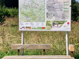
Directions:
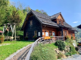
From the bus stop, the trail climbs to the miners' house, where two benches invite you to take a break after visiting the miners' house. Afterwards, the somewhat steep and asphalted road goes uphill until you reach a fork after approx. 1.7 km. Gearade upwards (hut), an old road goes past the Seebacher directly to the Mooshöhe. However, you can also continue along the road following the markings.
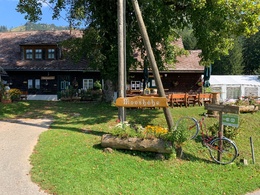
Tip:
The Jausenstation is closed on Mondays, but honest guests can get drinks in the adjacent building, well chilled in the fountain.
Additional information:
Die Jausenstation Mooshöhe ist von Mai bis Oktober geöffnet, Montag ist Ruhetag
Starting point: Unterlaussa
Destination: nature.bench.paths Mooshöhe
further information:
- Board possible
Accessibility / arrival
Public Transit
By car from Linz: A1 motorway exit Enns-Steyr > B115 via Altenmarkt to Unterlaussa
By car from Vienna: A1 motorway exit Amstetten West > Waidhofen / Ybbs > Weyer > Altenmarkt > Unterlaussa
Most economical season
- Spring
- Summer
- Autumn
Please get in touch for more information.
Stadtplatz 27
4400 Steyr
Phone +43 7252 53229 - 0
E-Mail info@steyr-nationalpark.at
Web www.steyr-nationalpark.at/
https://www.steyr-nationalpark.at/
Interactive elevation profile
Create PDF
Tour-Details
Starting place: 3335 Weyer
Destination: 3335 Weyer
duration: 1h 4m
length: 2,9 km
Altitude difference (uphill): 300m
Lowest point: 540m
Highest point: 846m
difficulty: medium
condition: medium
panoramic view: Great panorama
Paths covering:
Asphalt, Gravel, Street, Hiking trail, Other
powered by TOURDATA