

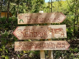
Kühberg


Interactive elevation profile
Create PDF
Tour-Details
Starting place: 4464 Kleinreifling
Destination: 3335 Weyer
duration: 1h 34m
length: 3,6 km
Altitude difference (uphill): 583m
Altitude difference (downhill): 10m
Lowest point: 821m
Highest point: 1.404m
Paths covering:
Path / trail, Gravel
powered by TOURDATA
Short description:
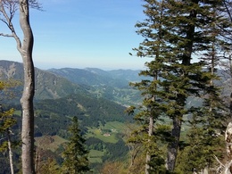
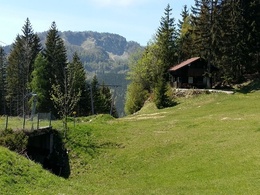
Summit tour on the Viehtaleralm to the Kühberg with numerous viewpoints
Summit tour on the Viehtaleralm to the Kühberg with numerous viewpoints
Recommended season:
- April
- May
- June
- July
- August
- September
- October
Properties:
- Round trip
- Scenic
- Geological highlights
- Summit route
From the Viehtaleralm the trail leads past the Niglalm on the forest road and then at the former ski area constantly uphill to the Kühberg.
Trail number: 497
Directions:
The starting point is at the parking lot of the Viehtaleralm and the trail leads first on the forest road past the Niglalm and Sonnriß. It goes constantly uphill over alpine pastures, meadows and after the so-called transition finally through the forest to the summit of this mountain with a great view.
Tip:
No gastronomy along the way, so bring drinks and a snack if needed.
Starting point: Weyer/Kleinreifling - Viehtaleralm
Destination: Weyer/Kleinreifling - Kühberg
Accessibility / arrival
Public Transit
The Ennstalbahn runs between Linz and Weißenbach-St. Gallen.
Parking
Weyer/Kleinreifling - Viehtaleralm
Getting there
From Salzburg/Linz: A1 motorway exit Enns-Steyr > B115 into the Enns Valley
From Vienna: A1 motorway exit Haag > B42 > B122 > B115 into the Enns Valley
From Passau: A8 Passau > Wels > A1 motorway exit Enns-Steyr > B115 into the Enns Valley
From Graz: A9 Pyhrnautobahn > motorway exit Klaus > Grünburg > into the Ennstal Valley
Public Transit
The Ennstalbahn runs between Linz and Weißenbach-St. Gallen.
Details at www.ooevv.at
Railway Stations are located in Steyr, Garsten, Lahrndorf, Dürnbach, Ternberg, Trattenbach, Losenstein, Reichraming, Großraming, Gaflenz, Weyer, Küpfern, Kastenreith, Kleinreifling and Weißenbach-St. Gallen.
Parking
Weyer/Kleinreifling - Viehtaleralm
Most economical season
- Spring
- Summer
- Autumn
Please get in touch for more information.
Stadtplatz 27
4400 Steyr
Phone +43 7252 53229 - 0
E-Mail info@steyr-nationalpark.at
Web www.steyr-nationalpark.at/
https://www.steyr-nationalpark.at/
Interactive elevation profile
Create PDF
Tour-Details
Starting place: 4464 Kleinreifling
Destination: 3335 Weyer
duration: 1h 34m
length: 3,6 km
Altitude difference (uphill): 583m
Altitude difference (downhill): 10m
Lowest point: 821m
Highest point: 1.404m
Paths covering:
Path / trail, Gravel
powered by TOURDATA