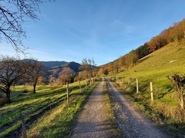
Arthofberg
4400 Steyr

Circular route with a short variant over the Arthofberg summit and the longer path leads all around.
Recommended season:
- January
- February
- March
- April
- May
- June
- July
- August
- September
- October
- November
- December
- Loop
- Scenic
- Geological highlights
Starting from Pension Pfaffenlehen (Unterbuchschachner family), the path leads to the Durchlaufner Saddle. There you decide for the shorter or the longer variant. The two paths reunite shortly before the Dichlberger Chapel and after the Katzberg farmhouse, it goes left over a grass ridge down to the Pfaffenlehen campsite and back to the starting point.
Hiking trail: E34, E34a, E34b
Directions:Past the Scholler farmhouse, a narrow agricultural road leads to "Schollerreit," where a bench invites you to rest and offers a beautiful view of the Maria Neustift pilgrimage church. Continuing along the agricultural road, past the Glasnerhäusl, you reach a crossroads after about 45 minutes. The hiking trail leads left to the Durchlauf farmhouse and the Durchlaufner Chapel from 1926. A farm road continues up to the Durchlaufner Saddle and then left to the next crossroads.
The shorter variant leads over the Arthofberg (E34a).
The longer variant swings right over a meadow to the Loidlhäusl. After 100 meters of asphalted road, you reach the Knappenweg, which comes up from Pechgraben (Großraming). Following the Knappenweg, you reach a saddle, where you turn left again. At the highest point of this hike (750m), a beautiful panorama opens up over the municipality of Maria Neustift including the town center.
Past the Dichlberg farmhouse, you again meet the short variant of the hiking trail, keep right and continue downhill on the asphalted road to the Dichlberger Chapel, whose history can be read inside.
The agricultural road towards the Katzberg farmhouse is partly blasted out of the rock, which, on close inspection, makes many mineralogical hearts beat faster. Past the Katzberg farmhouse, turn left and hike along a grass ridge, past the Pölzlehen house down to the campsite. Left uphill you reach the starting point again.
Paths covering:
further information:
- Flatly
Getting there
From Salzburg/Linz: A1 motorway exit Enns-Steyr > B115 into the Enns Valley
From Vienna: A1 motorway exit Haag > B42 > B122 > B115 into the Enns Valley
From Passau: A8 Passau > Wels > A1 motorway exit Enns-Steyr > B115 into the Enns Valley
From Graz: A9 Pyhrnautobahn > motorway exit Klaus > Grünburg > into the Ennstal Valley
Public Transit
The Ennstalbahn runs between Linz and Weißenbach-St. Gallen.
Details at www.ooevv.at
Railway Stations are located in Steyr, Garsten, Lahrndorf, Dürnbach, Ternberg, Trattenbach, Losenstein, Reichraming, Großraming, Gaflenz, Weyer, Küpfern, Kastenreith, Kleinreifling and Weißenbach-St. Gallen.
Parking
Maria Neustift/parking lot at Pension Pfaffenlehen or at the campsite
- Spring
- Summer
- Autumn
- Early winter
- Deep winter
Please get in touch for more information.
Stadtplatz 27
4400 Steyr
Phone +43 7252 53229 - 0
E-Mail info@steyr-nationalpark.at
Web www.steyr-nationalpark.at/


